


Click Image to Enlarge
Nebraska Counties
There is ninety-three counties in state of Nebraska. Despite the fact that Sarpy County contained the oldest settlement in the state, it was one of the last lands along the river to be recognized by law. Finally, on February 1, 1857, the land "where the cities meet the country" was officially created.Gosper County, Nebraska
Gosper County Education, Geography, and History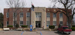
Gosper County is a county located in the state of Nebraska. Based on the 2010 census, the population was 2,044. Its county seat is
Elwood. The county was formed in 1873 and later organized in 1881. It was named after John J. Gosper, a Secretary of State of Nebraska.
Gosper County is part of the Lexington, NE Micropolitan Statistical Area.
Etymology - Origin of Gosper County Name
name of Nebraska Secretary of State John J. Gosper was chosen as the county name
Demographics:
County QuickFacts: CensusBureau Quick Facts
Gosper County History
Between 1873 and 1889, three different county seats
served the inhabitants of Gosper County. These continuing changes were due to
shifts in population that occurred during the 16-year period. As one might
imagine, each relocation of the county seat did not go unchallenged.
A growing interest in having an organized county government for this area
culminated when a petition requesting such was filed with Gov. Robert Furnas in
July 1873. A month later a proclamation was issued for the county's organization
and the name of Nebraska Secretary of State John J. Gosper was chosen as the
county name. Daviesville, the site of the area's first post office, was named
the county seat. It would not be until March 2, 1881, however, that the county's
organization was legalized and its boundaries officially established by the
Legislature.
In November 1873, county commissioners, who had been elected less than four
months earlier, authorized the construction of a courthouse in Daviesville. They
did not, however, appropriate the necessary funding and as a result a courthouse
was never built. For a number of years, officials kept county records and books
in their homes.
During those years a new settlement known as Homerville was developed with the
anticipation that the railroad would pass through it. Rapid growth of the
settlement led to an election in August 1882, and Homerville became the county
seat over two rivals. But the railroad never came to Homerville.
When the Burlington Railroad advanced westward toward Colorado, a townsite known
as Elwood was platted in 1885. It was just three years later that a bitterly
contested election ended with Elwood becoming the county seat. Homerville's
businessmen and inhabitants followed the courthouse to Elwood, which today
serves as the county seat. Fifty years after the local government offices were
relocated to Elwood, voters approved a $42,000 bond issue to match a Public
Works Administration grant to build the current courthouse.
Geography: Land and Water
As reported by the Census Bureau, the county has a total area of 463 square miles (1,200 km2), of which 458 square miles (1,190 km2) is land and 4.6 square miles (12 km2) (1.0%) is water
Neighboring Counties
Bordering counties are as follows:
- Phelps County (east)
- Furnas County (south)
- Frontier County (west)
- Dawson County (north)
Education


Click Image to Enlarge
