


Click Image to Enlarge
Nebraska Counties
There is ninety-three counties in state of Nebraska. Despite the fact that Sarpy County contained the oldest settlement in the state, it was one of the last lands along the river to be recognized by law. Finally, on February 1, 1857, the land "where the cities meet the country" was officially created.Hamilton County, Nebraska
Hamilton County Education, Geography, and History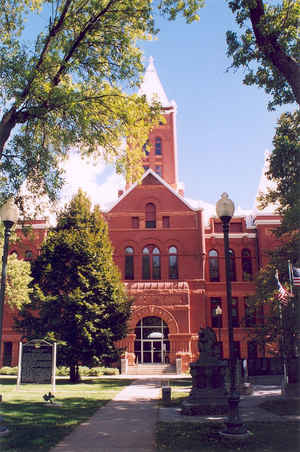
Hamilton County is a county located in the state Nebraska. Based on the 2010 census, the population was 9,124. Its county seat is Aurora.
The county was named for Alexander Hamilton, the first Secretary of the Treasury.
Hamilton County is included in the Grand Island, NE Metropolitan Statistical Area.
Etymology - Origin of Hamilton County Name
Namedin honor of Alexander Hamilton, who was Secretary of the Treasury in George Washington's cabinet.
Demographics:
County QuickFacts: CensusBureau Quick Facts
Hamilton County History
One-hundred years ago, what was
termed at the time as "one of the finest courthouses in Western Nebraska" burned
to the ground. But before 1894 came to a close, Hamilton County residents
rallied together and began work on a $60,000, three-story, brick and stone
courthouse. Next year Hamilton County residents will be rallying once more. This
time it will be to celebrate the centennial of their grand courthouse building.
Located on Central Park Square, in the heart of downtown Aurora, the
symmetrically-arranged courthouse features a tower on each corner and a center
tower measuring 150 feet high. Over the years, very few alternations have been
made to the courthouse. Much of its original ornate woodwork is still in place
today.
The 100-year-old courthouse is actually the third to serve the county, which was
organized in 1867 and named in honor of Alexander Hamilton, who was Secretary of
the Treasury in George Washington's cabinet. The county's first courthouse was
built in 1870 in a settlement named Orville City, which was platted along the
Blue River. Orville City was intent on remaining the county seat, despite
efforts to the contrary.
In 1873 a petition was filed to move the county seat to Aurora. An election
followed and Aurora prevailed. Commissioners, however, refused to move and a
court order was issued against them. The commissioners fought it up to the
Supreme Court, which ruled against Aurora.
Not to be deterred, Aurora residents brought the issue to a second vote of the
electorate the following year and again prevailed. The commissioners still
refused to move. At that point, 150 supporters of Aurora traveled to Orville
City and captured the county records. A court order, however, forced them to be
returned to the original county seat.
It would take three subsequent elections before Aurora finally became the county
seat. To ensure its victory would stand, Aurora townspeople in 1877 built,
without expense to the county, the courthouse that would eventually burn down in
1894.
Geography: Land and Water
As reported by the Census Bureau, the county has a total area of 547 square miles (1,420 km2), of which 543 square miles (1,410 km2) is
land and 4.1 square miles (11 km2) (0.8%) is water
Neighboring Counties
Bordering counties are as follows:
- Polk County (northeast)
- York County (east)
- Clay County (south)
- Hall County (west)
- Merrick County (north)
Education


Click Image to Enlarge
