


Click Image to Enlarge
Nebraska Counties
There is ninety-three counties in state of Nebraska. Despite the fact that Sarpy County contained the oldest settlement in the state, it was one of the last lands along the river to be recognized by law. Finally, on February 1, 1857, the land "where the cities meet the country" was officially created.Jefferson County, Nebraska
Jefferson County Education, Geography, and History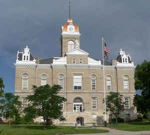
Jefferson County is a county located in the state of Nebraska. Based on the 2010 census, the population was 7,547. Its county seat is Fairbury. The county was named in honor of Thomas Jefferson, third President of the United States of America.
Etymology - Origin of Jefferson County Name
The county was named Jefferson in honor of Thomas Jefferson,
the third president of the United States.
Demographics:
County QuickFacts: CensusBureau Quick Facts
Jefferson County History
It has been claimed that if an
accurate map of the United States is folded from east to west and then from
north to south, the creases would intersect at the point where Jefferson County
is located on the map. Some believe this truly confirms that Jefferson County is
literally located in the center of the United States.
Long before Jefferson County was organized, this area was possibly the site of
one of the largest Indian battles on the American continent. It was reported
that in 1832, 16,000 warriors from the Pawnee and Sioux tribes engaged in a
battle near where the Big Sandy Creek joins the Little Blue River. After three
days of fighting, more than 5,000 warriors had died and the battle gave the
Pawnee control of the area.
Jefferson County was once part of a much larger county designated as Jones
County. The Legislature determined that Jones County's land area of 706,560
acres was too large so in 1870 it separated the area into Jefferson and Thayer
Counties. The county was named Jefferson in honor of Thomas Jefferson, the third
president of the United States.
The Oregon Trail and Pony Express Route both passed through what would become
Jefferson County, paralleling the Little Blue River. The famous Rock Creek
Station was built along the trails. History has it that James "Wild Bill" Hickok
first came into prominence as a result of a fight at the station. Hickok was
apparently tending stock for the Ben Halliday Stage Company at the station when
it was alleged that he killed three men. Hickok was put on trial in Beatrice and
pleaded self defense. When no one appeared at the trial to testify against him,
the case was dismissed.
The county seat of Fairbury was surveyed and platted along the Little Blue River
about a year before Jefferson County was organized. The settlement was a popular
place for the Otoe tribe to visit since it was close to their reservation.
Jefferson County's stately, ornate courthouse dates back to 1891 and is listed
on the National Register of Historic Places.
Geography: Land and Water
As reported by the Census Bureau, the county has a total area of 576 square miles (1,490 km2), of which 570 square miles (1,500 km2) is
land and 5.5 square miles (14 km2) (1.0%) is water.
Neighboring Counties
Bordering counties are as follows:
- Saline County - north
- Gage County - east
- Washington County, Kansas - south
- Republic County, Kansas - southwest
- Thayer County - west
- Fillmore County - northwest
Education


Click Image to Enlarge
