


Click Image to Enlarge
Nebraska Counties
There is ninety-three counties in state of Nebraska. Despite the fact that Sarpy County contained the oldest settlement in the state, it was one of the last lands along the river to be recognized by law. Finally, on February 1, 1857, the land "where the cities meet the country" was officially created.Saunders County, Nebraska
Saunders County Education, Geography, and History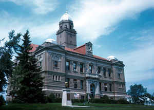
Saunders County is a county located in the state of Nebraska. Based on the 2010 census, the population was 20,780. Its county seat is
Wahoo.
Saunders County is included in the Omaha-Council Bluffs, NE-IA Metropolitan Statistical Area.
Etymology - Origin of Saunders County Name
Saunders County was created by the Territorial Legislature on Jan. 26, 1856 and at that time was named Calhoun County. But the name Calhoun was not popular among early settlers in the territory, as a government surveyor by that name was suspected of corruption and graft. So in 1862 the Territorial Legislature changed the county's name to Saunders, in honor of territorial Gov. Alvin Saunders.
Demographics:
County QuickFacts: CensusBureau Quick Facts
County History
Saunders County was created by the
Territorial Legislature on Jan. 26, 1856 and at that time was named Calhoun
County. But the name Calhoun was not popular among early settlers in the
territory, as a government surveyor by that name was suspected of corruption and
graft. So in 1862 the Territorial Legislature changed the county's name to
Saunders, in honor of territorial Gov. Alvin Saunders.
Ashland is believed to be the first settlement in the county. For many years the
area stretching north along the Platte River from Ashland to Leshara was home to
the Otoe Indians, while the Pawnee Indians were camped in the bluffs in the
northern part of the county.
When the first county election was held in 1866, the settlement of Ashland was
chosen as the county seat. In 1870 the county's first courthouse would be built
here. Ashland's status as home to this new county's government would be
short-lived, however, as in 1873 voters chose a more centrally located Wahoo.
Within a year a courthouse would be built in the new county seat and stand for
the next 30 years. By the beginning of the 20th century the county was in need
of a new home for its offices and in 1904 the present courthouse was built at a
cost of $87,000.
Located on the east lawn of the courthouse today is a replica of a Mark 14
torpedo, which stands as a memorial to the USS. Wahoo and its crew of 65 who
perished during World War II. The submarine was credited with sinking 20
Japanese ships before it was sunk by enemy action on Oct. 11, 1943. Each October
a memorial service is held at the courthouse to honor those who gave their lives
in submarine warfare.
A frequently-asked question is how the county seat received its unique name.
There are actually two versions that are used to provide the answer. The first
is that the name originates from an Indian word for a medicinal plant known as
the "burning bush," which grew along the banks of the Wahoo Creek. The second
explanation is the name is from the word "pahoo," which means "not very bluffy"
terrain.
Geography: Land and Water
As reported by the Census Bureau, the county has a total area of 760 square miles (2,000 km2), of which 750 square miles (1,900 km2) is
land and 9.6 square miles (25 km2) (1.3%) is water.
Neighboring Counties
Bordering counties are as follows:
- Douglas County (east)
- Sarpy County (east)
- Cass County (southeast)
- Lancaster County (south)
- Butler County (west)
- Dodge County (north)
Education


Click Image to Enlarge
