


Click Image to Enlarge
Nebraska Counties
There is ninety-three counties in state of Nebraska. Despite the fact that Sarpy County contained the oldest settlement in the state, it was one of the last lands along the river to be recognized by law. Finally, on February 1, 1857, the land "where the cities meet the country" was officially created.Sioux County, Nebraska
Sioux County Education, Geography, and History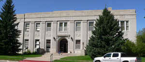
Sioux County is a county located in the state of Nebraska. Based on the 2010 census, the population was 1,311. Its county seat is
Harrison.
Sioux County is included in the Scottsbluff, NE Micropolitan Statistical Area.
Etymology - Origin of Sioux County Name
This area had been primarily left to the Sioux Indian tribe before the mid 1800s. The present Sioux County was long a base of operations for many of the Indian raids throughout Northwest Nebraska.
Demographics:
County QuickFacts: CensusBureau Quick Facts
Sioux County History
Once known as Beauvais Terras, or
badlands, it would take nearly 20 years after Nebraska was admitted to the Union
before action would be taken to organize this northwest region of the state. In
fact, for many years the area known as Sioux County actually consisted of what
today are 13 separate counties, stretching from Holt County westward to Wyoming.
This area had been primarily left to the Sioux Indian tribe before the mid
1800s. The present Sioux County was long a base of operations for many of the
Indian raids throughout Northwest Nebraska. It was also in the county that the
Indians made their final peace with the white man.
The boundaries for the initial Sioux County were established by the Legislature
in 1877. In February 1885 they were redefined to reflect the current boundaries.
With the railroad passing through the county the following year, a tent town
known as Bowen sprang up along the line. Years later it would become known as
Harrison and the site of the county seat. Five sites vied to become the county
seat and several interesting stories resulted. Bowen and Bodarc, located 12
miles to the northwest, were the principal contenders. Others were Andrews,
Montrose and the S-E Ranch.
When the election was conducted in January 1887, an old-time cowboy was assigned
to take Bodarc ballots to a polling site 50 miles away. He stopped for the night
in Bowen, where townspeople kept him at the card table with ample liquor. The
following morning he was handed another bottle and sent on his way. He arrived
at the polling site to discover his Bodarc ballots had been replaced by Bowen
ballots. Bowen easily won.
When it came time for a $10,000 bond issue election to build a courthouse, a
similar incident occurred. Before the ballots could be counted, several men
allegedly switched ballot boxes and the bond issue won easily.
The first courthouse was built in 1888 and stood for 42 years. In 1930 the
present courthouse was constructed.
Geography: Land and Water
As reported by the Census Bureau, the county has a total area of 2,067 square miles (5,350 km2), of which 2,067 square miles (5,350 km2)
is land and 0.7 square miles (1.8 km2) (0.03%) is water.
Neighboring Counties
Bordering counties are as follows:
- Fall River County, South Dakota - north
- Box Butte County - east
- Dawes County - east
- Scotts Bluff County - south
- Goshen County, Wyoming - southwest
- Niobrara County, Wyoming - northwest
Education


Click Image to Enlarge
