


Click Image to Enlarge
Nebraska Counties
There is ninety-three counties in state of Nebraska. Despite the fact that Sarpy County contained the oldest settlement in the state, it was one of the last lands along the river to be recognized by law. Finally, on February 1, 1857, the land "where the cities meet the country" was officially created.Washington County, Nebraska
Washington County Education, Geography, and History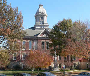
Washington County is a county located in the state of Nebraska. Based on the 2010 census, the population was 20,234. Its county seat is
Blair.
Washington County is included in the Omaha-Council Bluffs, NE-IA Metropolitan Statistical Area
Etymology - Origin of Washington County Name
Washington County's first boundaries were established by the Territorial Legislature on Feb. 22, 1855, the anniversary of President George Washington's birth. Thus, the county was named in his honor.
Demographics:
County QuickFacts: CensusBureau Quick Facts
Washington County History
Like many of those counties bordering
the Missouri River, Washington County's history dates back to the early 19th
century. On Aug. 3, 1804, Merriwether Lewis and William Clark held council with
six Indian chiefs on the western banks of the Missouri River. The site became
known as "Council Bluffs." At the suggestion of Lewis and Clark, this same site
later became Fort Atkinson in 1819.
Fort Atkinson, the first Union military post in Nebraska, was intended to bring
peace with the Indians and discourage British encroachment on fur trading with
Canada. It was once the largest military post of its day, as troops stationed
there numbered over 1,100. The fort served the Midwest until 1827, when it was
abandoned. Eventually the community of Fort Calhoun was established on the site.
Washington County's first boundaries were established by the Territorial
Legislature on Feb. 22, 1855, the anniversary of President George Washington's
birth. Thus, the county was named in his honor. Fort Calhoun was selected as the
county seat. When the boundaries were redefined three years later, the county
seat was moved to DeSoto. In 1869, by a popular vote, Blair was selected as the
county seat. The present courthouse was completed 20 years later at a cost of
about $50,000. Several additions have been made to the courthouse over the
years.
Washington County was originally slated to be the home of Nebraska's State
Capitol. In 1855 the town of Fontanelle, located in the western section of the
county and named after Omaha Indian Chief Logan Fontanelle, was platted
expressly for this purpose. It also was the first home of Nebraska University.
Plans for both eventually stalled and both facilities ended up being built in
Lincoln.
Just as it does today, farming played a key role in the early years. The Mormons
farmed in the south part of the area in 1847 and 1848 to supply food for their
brethren who were traveling to Utah. It was reported that soldiers stationed at
Fort Atkinson once grew 20,000 bushel of corn.
Geography: Land and Water
As reported by the Census Bureau, the county has a total area of 393 square miles (1,020 km2), of which 390 square miles (1,000 km2) is
land and 3.2 square miles (8.3 km2) (0.8%) is water.
It is the fifth-smallest county in Nebraska by area.
Neighboring Counties
Bordering counties are as follows:
- Burt County - north
- Harrison County, Iowa - northeast
- Pottawattamie County, Iowa - southeast
- Douglas County - south
- Dodge County - west
Education


Click Image to Enlarge
