


Click Image to Enlarge
Nebraska Counties
There is ninety-three counties in state of Nebraska. Despite the fact that Sarpy County contained the oldest settlement in the state, it was one of the last lands along the river to be recognized by law. Finally, on February 1, 1857, the land "where the cities meet the country" was officially created.Wheeler County, Nebraska
Wheeler County Education, Geography, and History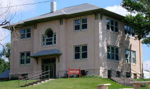
Wheeler County is a county located in the state of Nebraska. Based on the 2010 census, the population was 818. Its county seat is Bartlett. The county was formed in 1877 and later organized in 1881. It was named after Major Daniel H. Wheeler.
Etymology - Origin of Wheeler County Name
Named the county in honor of Maj. Daniel H. Wheeler, a long-time secretary of the Nebraska State Board of Agriculture.
Demographics:
County QuickFacts: CensusBureau Quick Facts
Wheeler County History
On Feb. 17, 1877, the boundaries of
Wheeler County were established by the Legislature and named the new county in
honor of Maj. Daniel H. Wheeler, a long-time secretary of the Nebraska State
Board of Agriculture. It would be four years later, however, that the county
would officially organize.
Gov. Albinus Nance appointed a special board of commissioners and a county clerk
who would be responsible for the organization efforts. At the time the county
was being organized it included the area that is today neighboring Garfield
County to the west. The commissioners agreed to meet at a county seat known as
Cedar City because it was a central location. Cedar City, so named because three
large cedar trees stood there, was located approximately six miles north of the
present town of Ericson.
In 1881 residents in the western half of the county proposed their area should
become a separate county and in November of that year Wheeler County was
divided.
The question of where Wheeler County should locate its government offices became
an important topic in 1885. Cumminsville, the first townsite in the county,
sought the honor. So too did an area just south of where Bartlett is located
today. The Bartlett site offered several incentives, including land on which to
build a courthouse. After two special elections, Bartlett was selected over
Cumminsville by a vote of 193 to 90.
A modest courthouse was soon built in Bartlett. A fire-proof brick vault was
built in Ericson to hold valuable county records. This decision proved to be
wise, as in 1909 the courthouse was destroyed by fire. Ericson made an effort to
relocate the county seat there. But in a special election, voters rejected the
idea and instead approved a $5,000 expenditure to replace the courthouse. This
structure was completed in 1920.
In 1976 the courthouse building was condemned by the State Fire Marshal.
Concerned citizens began efforts to replace it. After more than six years of
study, the present courthouse was completed in May 1982.
Geography: Land and Water
As reported by the Census Bureau, the county has a total area of 576 square miles (1,490 km2), of which 575 square miles (1,490 km2) is
land and 0.4 square miles (1.0 km2) (0.07%) is water.
Neighboring Counties
Bordering counties are as follows:
- Antelope County (northeast)
- Boone County (southeast)
- Greeley County (south)
- Garfield County (west)
- Holt County (north)
Education


Click Image to Enlarge
