

Click Image to Enlarge
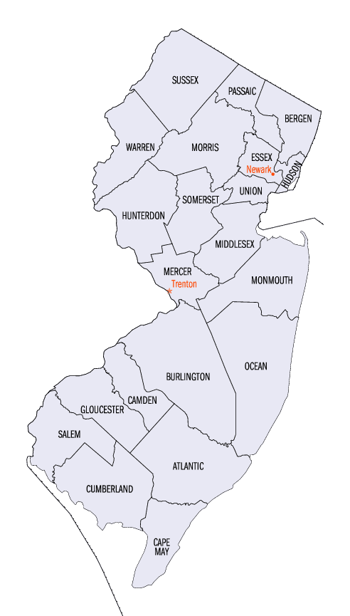
New Jersey Counties
New Jersey has twenty-one counties. New Jersey's first counties were created as administrative districts within each province, with East Jersey split in 1675 into Bergen, Essex, Middlesex and Monmouth counties, while West Jersey's initial counties of Burlington and Salem date to 1681. The most recent county created in New Jersey was Union County, created in 1857.Atlantic County, New Jersey
Atlantic County Education, Geography, and History
Atlantic County is a county located in the state of New Jersey. Based on the 2010 census, the county had a population
of 274,549. All of what is known today as Atlantic County was once called Egg Harbor Township, the eastern half of the original County of
Gloucester. Named as an official district as early as 1693. The county was formally created from portions of Gloucester County as of
February 7, 1837, and consisted of the townships of Egg Harbor, Galloway, Hamilton and Weymouth. Its county seat is Mays Landing.
This county forms the Atlantic City-Hammonton Metropolitan Statistical Area, which is also part of the Delaware Valley Combined
Statistical Area
Etymology - Origin of Atlantic County Name
Atlantic is named for the Atlantic Oceanwhich forms the county's eastern border
Demographics:
County QuickFacts: CensusBureau Quick Facts
Atlantic County History
In 1664, Charles II of England granted his brother, James, Duke of York, the land between the Hudson and Delaware
Rivers. James presented the land to two favorites: John, Lord Berkeley and Sir George Carteret. He named the new land
Nova Caesarea. Today the boundaries of Nova Caesarea (New Jersey) are exactly as set about in the original Duke of
York's deed.
Southern New Jersey was the home of the LENI-LENAPE Indians. It was explored in the 16th century by Dutch, French,
Swedish, Finnish and Portuguese sea captains. The first survey was made by Henry Hudson in 1609. Cornelius Jacobsun Mey
sailed into Little Egg Harbor in 1614 and later charted the coastline.
Early Settlers
The first settlement in Atlantic County was in Somers Point. In 1693, John Somers, a member of the Quaker Society
of Friends, was appointed by the Cape May County Court as supervisor of roads and constable of Great Egg Harbor. The
following year, Egg Harbor was made a part of the Old Gloucester County. At that same time, a ferry was established
from Beesley's Point to Somers Point. In 1695, John Somers purchased from Thomas Budd, 3000 acres of land around
Somers Point. Also purchasing land from Mr. Budd were John Clement, Jonathan Adams, Paul Scull, Jonas Balentine and
Peter Conover.
Daniel Leeds, our first surveyor, made extensive surveys of Egg Harbor in 1698, thus founding Leeds Point. A
descendant of his, Jeremiah Leeds became the first permanent resident of ABSECON ISLAND and later acquired title to
nearly all of Atlantic City. His son, Chalkley Leeds, became the first mayor of Atlantic City. George May settled in
Mays Landing in the early eighteenth century. Thus, Mays Landing was named for George May not Cornelius Jacobsun Mey.
Master Commandant RICHARD SOMERS became a naval hero and is buried near the walls of Tripoli. A member of the
well-known Lake family of inventors from Pleasantville, US engineer SIMON LAKE invented the first submarine.
Many of the early settlers were whale men. Shipyards, mills, iron furnaces and brick yards were all active in the
region. SHIP BUILDING became a major industry. Prior to the Revolutionary War and War of 1812, numerous ships
reached our beaches. Southern New Jersey was developing a cultural and social life all its own.
A New County
As early New Jersey settlements grew and developed, each had their own unique identities. These settlements
included: BRIGANTINE , HAMMONTON , PLEASANTVILLE AND EGG HARBOR CITY. In February of 1837, Atlantic County (formerly
known as Egg Harbor) was carved from Gloucester County with boundaries that have remained substantially the same to
this date. The county is bounded on the north by the Mullica River; on the south by the Great Egg Harbor Bay and the
Tuckahoe River; on the west by Camden and Gloucester Counties; and on the east by the Atlantic Ocean.
The County Seat was established in Mays Landing in 1837 and a courthouse built there in 1838 where it remains in use
today. The first Board of Freeholders was established in 1837 in Mays Landing with representatives from four
townships: Galloway, Hamilton, Egg Harbor and Weymouth. Mrs. Rebecca Estell Winston was the first woman to serve as
mayor in Atlantic County and was mayor of Estell Manor in 1925. As townships and municipalities grew, the board grew
as well. In 1967, however, the State Legislature changed the size to a seven-person-at-large County Board until 1975
when a new charter came into effect.
The County governmental form changed from Optional County Charter Law to the Executive Form in 1974. The
Administrative Code was adopted in May of 1976 and amended in 1992. Today, Atlantic County land area covers 561.01
square miles and is incorporated into 23 municipalities. Estimated county population in the 1994 census was 232,231.
The roots of local government in Atlantic County are long-standing. While community sizes and government forms vary,
the commitment to citizen-service is well-developed and still a matter of pride.
1. Atlantic County Past & Present , [Atlantic County, NJ]: Atlantic County Cultural Heritage Commission, 1976.
2. Encyclopaedia Britannica, 15th ed., "Simon Lake".
3. Nelson, William. The Indians of New Jersey. Paterson, NJ : The Press Publications, 1894.
4. Bock, William Sauts Netamuxwe. The Coloring Book of the First Americans. Wallingford, PA : Middle Atlantic Press, 1974.
5. Penn, William. William Penn's own account of the Leni Lenape or Delaware Indians. Revised edition by Albert Cook Myers. Wallingford, PA : Middle Atlantic Press, 1970.
6. Indians of Southern New Jersey. Woodbury, NJ : Gloucester County Historical Society, 1932.
7. Atlantic County, NJ. County of Atlantic Manual (1997).
8. [Atlantic County, NJ]. New Jersey Tercentenary: Historama of Atlantic County (1964).
9. [Atlantic County, NJ]. Historic Atlantic County (undated).
10. Blake, Mrs. Georgiana C. "Early Atlantic County". Atlantic City Press, 1934.
11. New Jersey. Atlantic County Division of Economic Development, Atlantic County, NJ (undated).
12. Wilbur, W.H. and Hand, W.B. Illustrated history of the town of Hammonton. [Hammonton, NJ] : Mirror Stream Printing, 1889.
13. Richard Somers 1778-1804" Master Commandant of the US Navy, compiled by Edna Miriam Hoopes. Atlantic City, NJ : [s.n.], 1933.
14. Municipal Databook. Palo Alto, CA : Info Publications, 1997.
Geography: Land and Water
As reported by the Census Bureau, the county has a total area of 671 square miles (1,739 km2), of which, 561
square miles (1,453 km2) of it is land and 110 square miles (286 km2) of it (16.44%) is water.
Topographically, much of Atlantic County is low-lying and flat. The highest elevation, approximately 150 feet (50 m)
above sea level, is found at two areas next to the NJ Transit passenger rail line just east of Hammonton. Sea level
is the lowest point.
Neighboring Counties
Bordering counties are as follows:
- Burlington County, New Jersey - north
- Ocean County, New Jersey - northeast
- Cape May County, New Jersey - south
- Cumberland County, New Jersey - southwest
- Camden County, New Jersey - northwest
- Gloucester County, New Jersey - northwest
Education


Click Image to Enlarge
