

Click Image to Enlarge
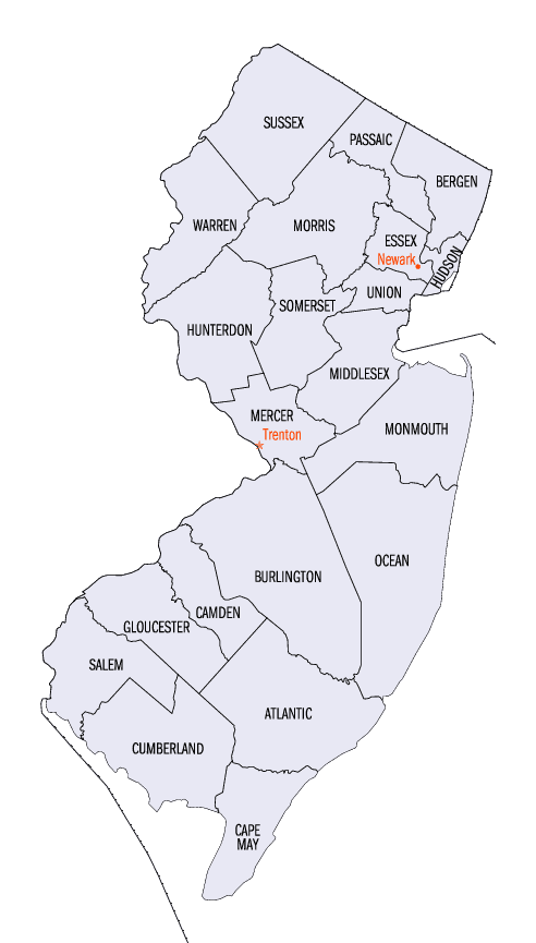
New Jersey Counties
New Jersey has twenty-one counties. New Jersey's first counties were created as administrative districts within each province, with East Jersey split in 1675 into Bergen, Essex, Middlesex and Monmouth counties, while West Jersey's initial counties of Burlington and Salem date to 1681. The most recent county created in New Jersey was Union County, created in 1857.Camden County, New Jersey
Camden County Education, Geography, and History
Camden County is a county located in the state of New Jersey. Its county seat is Camden. Based on the 2010 census, the population was
513,657. It was formed on March 13, 1844, from portions of Gloucester County. The county was named for Charles Pratt, 1st Earl Camden, a
British judge, civil libertarian, and defender of the American cause
The county is part of the Camden, NJ Metropolitan Division of the Philadelphia-Camden-Wilmington, PA-NJ-DE-MD / Delaware Valley Metropolitan
Statistical Area.
Etymology - Origin of Camden County Name
Camden is named for the Earl of Camden.
Demographics:
County QuickFacts: CensusBureau Quick Facts
Camden County History
A Brief History of Camden County
By Gail Greenberg
"Let it be remembered," wrote Thomas Sharp in 1718, "That upon the nineteenth day of September, in the year of
our Lord one thousand six hundred and eighty-one, Mark Newby, William Bates, Thomas Thackara, George Goldsmith and
Thomas Sharp set sail from the harbor...of Dublin...We took our land in tract together...bounding in the forks of
Newton Creek and so over to Cooper's Creek..." Sharp's narrative account of the first permanent European settlement
in what is today West Collingswood is the most accurate history of the establishment of Camden County.
Many of the early settlers in late seventeenth and early eighteenth century West Jersey (modern-day South Jersey)
were like the Newton Colony people. Quakers, members of the Society of Friends, were persecuted in England for their
religious beliefs and way of life. They came, lured by the Concessions and Agreements, a document written in 1677 by
proprietors such as William Penn, who owned a large portion of the land in West Jersey and wished to encourage
Quaker settlement in the area. The settlement offered the promise of religious freedom, equitable taxation, and
representative government.
Quakers were not the first people to arrive on New Jersey's shores. Some 13,000-15,000 years earlier, after a long
migration eastward beginning in Asia and leading over the Bering Strait through Alaska and across the American
continent, the Paleo-Indians (Old Stone Age peoples), whose descendants eventually became known as the Lenape, had
arrived. The Lenape were peace-loving, semi-nomadic people who lived in small family groups along the banks of
waterways, spoke an Algonkian language, farmed, hunted, and fished.
According to Herbert Kraft, author of The Lenape, published in 1986 by the New Jersey Historical Society, "Lenape"
in the Unami dialect meant "our men," "men of the same nation," or "common people." Names such as Delaware, Munsi,
Lenape, Unami, etc. are 17th and 18th century appellations that did not exist at the time of European contact: as a
matter of fact, Kraft states, the Lenape Indians "...were not a tribe in any political sense." To the explorers who
encountered them along the Delaware River they simply became known as "the Delaware."
The Quakers had also been preceded by a small band of Dutch families sent by the Dutch West India Company to
establish a minor trading and fur post on the Delaware River. Fort Nassau, probably established in 1626 near today's
Gloucester City, continued in use however for only about 25 years; it was taken over in turn by the English and the
Swedes and again came under the authority of the Dutch. Finally, it was ordered dismantled by Peter Stuyvesant in
1651. Thirteen years later the English again triumphed in New Jersey, and the Dutch were forced to cede the entire
colony.
Camden County's institutions, municipalities, and streets still bear the names of many of those who made this area
their new home. Elizabeth Haddon, immortalized by Henry Wadsworth Longfellow in Tales Of A Wayside Inn, arrived
alone in 1701 to look after her father's land claims and gave the family name to "Haddon's Field." She married John
Estaugh, a Quaker minister with whom she had an acquaintance in England. Elizabeth herself was much esteemed by the
Friends and was a minister in her own right.
Early settlers also included William and Benjamin Cooper, whose descendants founded Cooper Hospital and Coopers
Ferry, as well as the Kaighns, Gills, Stokes, Collings, Coles, Ellises, Zanes, Burroughs, Kays, Morgans, Matlacks,
and many others.
A ferry operated as early as 1688 by William Royden, then by William Cooper, and after 1693, by Cooper's son. Daniel
provided the earliest means of communication and transportation between the two colonies on the Delaware River. For
nearly a century, the settlement that grew up around it was known as Coopers Ferry. It became a center of activity
during the Revolutionary War period (1777-1778) while the British occupied Philadelphia. British troops often
crossed the river, disembarking at the ferry landing near the Benjamin Cooper House (Point and Erie Streets) to
forage for food supplies in the surrounding countryside.
Because Quakers opposed war and most would not bear arms for either side, many of the sect were harassed and
imprisoned. Military skirmishes in the area involved such well-known figures as General "Mad" Anthony Wayne , the
young Marquis de Lafayette, who earned a command for his attack on British forces near today's Gloucester City in
November 1777, and the Polish count Casimir Pulaski.
Even though in 1764 William Cooper's great-grandson, Jacob, purchased land for subdivision in what is today known as
Camden, few homes were established there until well after the Revolutionary War. By the close of that period only
three houses had been erected between Third Street and the Cooper River, and all belonged to members of the Cooper
family. The namesake of the new settlement was Charles Pratt, Earl of Camden, an English nobleman who supported the
American cause in Parliament.
In 1803 additional lots were laid out north and south of Arch Street between Front and Fifth Streets. In 1820,
Edward Sharp, envisioning a bridge and ferry system between Camden and Philadelphia, broadened the enclosure from
the south side of Federal Street to just beyond today's Mickle Boulevard, from the river to Fifth Street and called
it Camden Village.
Nonetheless, the City did not really begin to grow until 1834. The coming of Camden and Amboy Railroad helped spur
its population growth to 9,500 by mid-century. In 1838, a canal had been cut through Windmill Island in the middle
of the Delaware River, making ferry travel easier under all weather conditions. This shortened commuter time
combined with an increasing number of businesses and services made Camden an attractive place to live.
During the period following Camden County's separation from Gloucester County in 1844, the county population, having
expanded greatly, exceeded 25,000. In 1853 a new county courthouse designed by noted architect Samuel Sloan was
erected halfway between Market and Federal Streets. That same year the Camden and Atlantic Railroad (later the
Pennsylvania Railroad) began its first run from Camden to Haddonfield. The following year, it was extended to almost
Atlantic City.
Later, during the Civil War, many Camden residents supported and fought for the Union cause. The Zouaves, a
volunteer company, was the first to apply for service in state regiments. They fought at Antietam, Manassas,
Fredericksburg, Chancellorsville, Gettysburg, Spotsylvania, and in the Wilderness Campaign. They marched with
Sherman, fought in the Shenandoah Valley, and served under courageous officers such as General William Joyce Sewell.
Those who died are memorialized at the Gettysburg Battlefield and by the Soldiers' Monument at Haddon Avenue and
Mickle Boulevard next to Cooper Hospital.
The postwar period brought the poet Walt Whitman to Camden, where he first lived with his brother, George, on
Stevens Street and later at 330 Mickle Street, today a National Historic Landmark maintained by the State of New
Jersey. Whitman prepared the final or "deathbed edition" of Leaves of Grass in the Mickle Street house.
Portions of Specimen Days, a long essay on nature in diary form, was written during the summer months Whitman spent
convalescing at Laurel Springs. The poet's remains rest in a mausoleum of his own design in Camden's Harleigh
Cemetery, a late-Victorian burial ground in the park-lawn style.
The end of the nineteenth century marked the beginning of Camden's emergence as an industrial and commercial leader.
Eldridge Johnson's machine shop gave way to the Victor Talking Machine Company, predecessor of RCA, which ended its
presence in the city in 1988.
In 1869 Joseph Campbell and Abram Anderson founded a preserving company that eventually became known as The Campbell
Soup Company. The company flourished in the city of Camden during the next century. Although the company relocated
its processing facilities, the corporate headquarters is still located in the city.
The Esterbrook Pen and New York Ship Building companies had established themselves in Camden before World War I. By
then a popular saying was, "On Camden's supplies, the world relies." Immigrant labor seeking economic opportunity
helped increase the city population, providing a welcome source of abundant and cheap labor for the many industries
that sprung up. Cigars, sausages, patent drugs, leather goods, iron products, ships, linoleum, carriage bodies, gas
mantles, and terra cotta items were among the hundreds of products manufactured in the county.
In 1926, President Calvin Coolidge dedicated the Delaware River Bridge, later renamed for Benjamin Franklin. It
opened the way for commuters to work in Philadelphia and live in the Camden suburbs. A second bridge, the Walt
Whitman, opened 31 years later, connecting Philadelphia and Gloucester City. In 1976, the Betsy Ross Bridge, linking
Philadelphia and Pennsauken, opened to traffic.
These routes and the development of high-speed rail transportation between Camden and Philadelphia helped to push
the county's population over the half-million mark. This, combined with a broad economic and industrial base,
several centers for higher education, three major hospitals, and an excellent interstate road system and
connections, offer a bright future for the county.
Geography: Land and Water
According to the 2010 Census, the county had a total area of 227.293 square miles (588.69 km2), including 221.263 square miles (573.07 km2)
of land (97.3%) and 6.030 square miles (15.62 km2) of water (2.7%).
Located in a coastal / alluvial plain, the county is uniformly flat and low-lying. The highest points are a survey benchmark near the
Burlington County line at 219 feet (67 m) above sea level. The low point is sea level, along the Delaware River
Neighboring Counties
Bordering counties are as follows:
- Burlington County, New Jersey - northeast
- Atlantic County, New Jersey - southeast
- Gloucester County, New Jersey - southwest
- Philadelphia, Pennsylvania - northwest
Education
Camden County College is a two-year public community college serving students from Camden County. the school has campuses in Blackwood,
Camden and Cherry Hill and was founded in 1967.
Rutgers University-Camden is located in the downtown/waterfront district of Camden, and dates back to 1926 with the founding of the South
Jersey Law School.
The Rowan University School of Osteopathic Medicine is located in Stratford and dates to 1976. It is the state's only osteopathic medical
school and was South Jersey's first four-year college of medicine.
The Cooper Medical School of Rowan University is located in the downtown/university district of Camden. Established as a four-year medical
school in 1975, the relationship with Rowan University was formed in 2008.


Click Image to Enlarge
