

Click Image to Enlarge
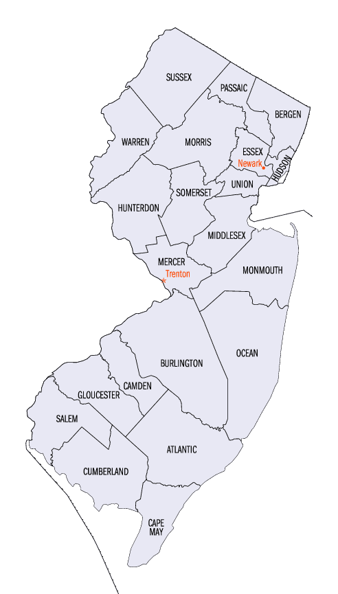
New Jersey Counties
New Jersey has twenty-one counties. New Jersey's first counties were created as administrative districts within each province, with East Jersey split in 1675 into Bergen, Essex, Middlesex and Monmouth counties, while West Jersey's initial counties of Burlington and Salem date to 1681. The most recent county created in New Jersey was Union County, created in 1857.Cumberland County, New Jersey
Cumberland County Education, Geography, and History
Cumberland County is a county located in the state of New Jersey. Based on the 2010 census, the population was 156,898. Its
county seat is Bridgeton. Cumberland County is named for Prince William, Duke of Cumberland. The county was formally created from portions of
Salem County as of January 19, 1748.
This county is part of the Vineland-Millville-Bridgeton Primary Metropolitan Statistical Area as well as the Delaware Valley Combined
Statistical Area
Etymology - Origin of Cumberland County Name
Cumberland is named for the Earl of Cumberland.
Demographics:
County QuickFacts: CensusBureau Quick Facts
Cumberland County History
The Colonial Legislature, at a session held January 30, 1748, passed an Act stipulating the east side of Salem County
as a new county to be known as Cumberland. It was so named by Governor Jonathan Belcher in honor of his patron, William
Augustus, Duke of Cumberland, brother of the king and the victor over "Bonnie Prince Charles", (Stuart) the Young
Pretender to the throne of England whose hopes were quenched at the bloody Battle of Culloden Moor.
The Act establishing the new county divided it into six townships: Greenwich , Hopewell , Stow Creek, Deerfield ,
Fairfield , and Maurice River. The Legislature ordered the Freeholders to meet first at Cohansey Bridge, which is now
Bridgeton, to arrange for the taking of a poll to determine the location of the county seat. The first court was held at
Greenwich. In December of the same year, 1748, Cohansey Bridge (now Bridgeton) was chosen as the seat of county
government. The selection was a compromise with Greenwich, Fairfield, and Deerfield contending for the honor, the
convenience, and the practical advantage from a business standpoint.
In 1752, Cumberland County's first court house, (Cumberland has had four) was built in the center of what is now West
Broad Street, east of the line of Franklin Street. During the next 15 years Cumberland County developed rapidly. At the
same time dissatisfaction over Colonial rule was increasing, a feeling that brought about eventual separation from the
British Crown. In 1772, Cumberland County elected two representatives to the Colonial Legislature. Theretofore, Salem
and Cumberland had been jointly represented. When Downe Township was established in 1772, it was named after Governor
William Franklin's wife, Elizabeth Downes, whose name was misspelled in the printed legislation and has been misspelled
ever since
Geography: Land and Water
According to the 2010 Census, the county had a total area of 677.62 square miles (1,755.0 km2), including 483.70 square miles (1,252.8 km2)
of land (71.4%) and 193.92 square miles (502.3 km2) of water (28.6%).
Cumberland is a low-lying, generally featureless coastal county, with many salt marshes near the Delaware Bay. The highest elevation is at one
of 12 areas in Upper Deerfield Township that stand approximately 140 feet (43 m) above sea level; the lowest elevation is sea level.
Neighboring Counties
Bordering counties are as follows:
- Gloucester County, New Jersey - north
- Atlantic County, New Jersey - northeast
- Cape May County, New Jersey - southeast
- Kent County, Delaware - southwest1
- Salem County, New Jersey - northwest
1across Delaware Bay; no land border
Education


Click Image to Enlarge
