

Click Image to Enlarge
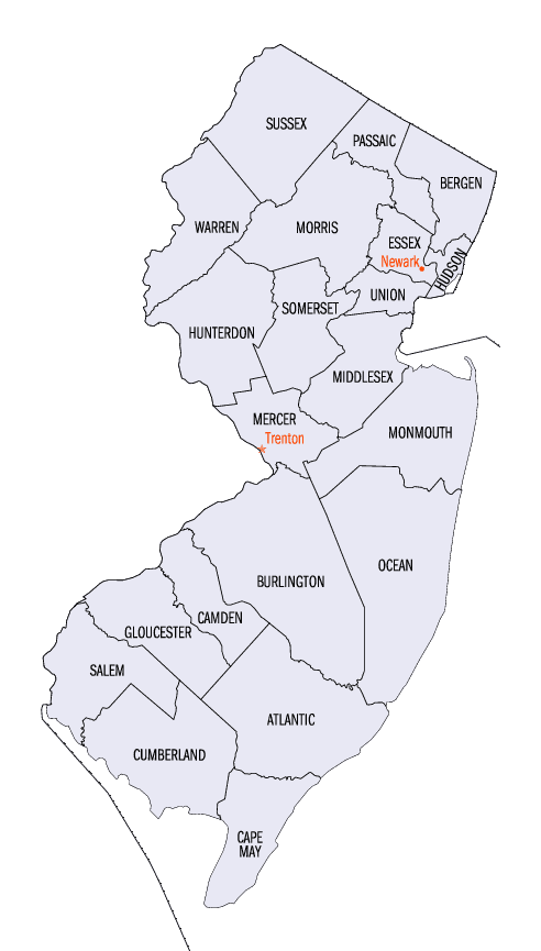
New Jersey Counties
New Jersey has twenty-one counties. New Jersey's first counties were created as administrative districts within each province, with East Jersey split in 1675 into Bergen, Essex, Middlesex and Monmouth counties, while West Jersey's initial counties of Burlington and Salem date to 1681. The most recent county created in New Jersey was Union County, created in 1857.Hunterdon County, New Jersey
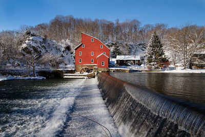
Hunterdon County Education, Geography, and History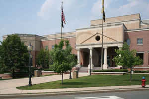
Hunterdon County is a county located in the western section of the state of New Jersey. Based on the 2010 census, the
population was 128,349. It is part of the New York Metropolitan Area. Its county seat is Flemington.
Hunterdon County was established on March 11, 1714, separating from Burlington County, at which time it included all of present-day Morris,
Sussex and Warren counties. The rolling hills and rich soils which produce bountiful agricultural crops drew Native American tribes and then
Europeans to the area.
It is part of the Newark-Union, NJ-PA Metropolitan Division of the New York-Northern New Jersey-Long Island, NY-NJ-PA Metropolitan Statistical
Area.
Etymology - Origin of Hunterdon County Name
Hunterdon is named for Robert Hunter, the colonial Governor of New Jersey from 1710 to 1719.
Demographics:
County QuickFacts: CensusBureau Quick Facts
Hunterdon County History
Hunterdon County was separated from Burlington County on March 11, 1714. At that time Hunterdon County was large, going from Assunpink
Creek near Trenton to the New York State line which at that time was about 10 miles (16 km) north of Port Jervis, New York. Hunterdon County
was named for Robert Hunter, a colonial governor of New Jersey. Language changes over time and location, so by stemming of [s], and a [t]
[d] lenition of the name of his family seat of "Hunterston" in Ayrshire, Scotland, the name "Hunterdon" was derived.
On March 15, 1739, Morris County (which at the time included what would later become Sussex County and Warren County) was separated from
Hunterdon County. The boundary between Hunterdon and Somerset counties is evidence of the old Keith Line which separated the provinces of West
Jersey and East Jersey.
Prior to 1714 the land that is now Hunterdon County laid entirely in Burlington County and included what is now Sussex,
Warren and Morris Counties and a portion of Mercer County.
The Lenni Lenape Indians or "Original People"lived in Hunterdon County.
Two of the tribes, the Minsi and Unami, were thought to live here.
A survey taken between 1912 and 1915 discovered 462 camps, villages, burial sites and rock shelters within Hunterdon
County .
Hunterdon County is named for Governor Robert Hunter for the name of his old world home, Hunterston rather than merely
his surname.
The First 275 Years of Hunterdon County - 1714 to 1989 (Downloadable book published by the Hunterdon County Cultural and Heritage Commission) - The book was published in 1989 in commemoration of the 275th Anniversary of the founding of Hunterdon County.
Geography: Land and Water
According to the 2010 Census, the county had a total area of 437.44 square miles (1,133.0 km2), including 427.82 square miles (1,108.0 km2)
of land (97.8%) and 9.62 square miles (24.9 km2) of water (2.2%).
Much of the county is hilly, with several hills rising to one thousand foot in elevation. The highest points are two areas in Lebanon
Township, one on the Morris County line, both reaching approximately 1,060 feet (320 m) above sea level. The first is at Smith on the Morris
County line and the second is north of the area called Little Brook. This area is known as the Highlands of New Jersey. The lowest elevation
is where the Mercer County line reaches the Delaware River, approximately 50 feet (15 m) above sea level. The county is drained by the
Musconetcong River in the north. The river flows in a southwest direction. The Lamington River drains the county in the east. The central
portion of the county is drained by the South Branch of the Raritan River. The Delaware River drains the western side of the county.
Neighboring Counties
Bordering counties are as follows:
- Warren County, New Jersey - north
- Morris County, New Jersey - northeast
- Somerset County, New Jersey - east
- Mercer County, New Jersey - southeast
- Bucks County, Pennsylvania - west
Education
Higher education
- Raritan Valley Community College is the two-year community college for both Hunterdon and Somerset County, one of a network of 19 county colleges statewide. Founded in 1965, the school's main campus is located in North Branch.
- Rutgers University has a partnership with Raritan Valley Community College which offers bachelor's degree completion programs at the North Branch campus.


Click Image to Enlarge
