

Click Image to Enlarge
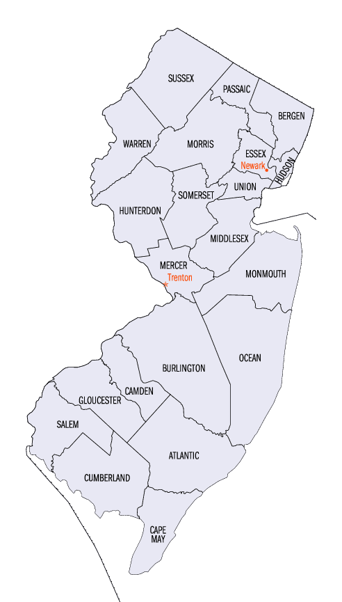
New Jersey Counties
New Jersey has twenty-one counties. New Jersey's first counties were created as administrative districts within each province, with East Jersey split in 1675 into Bergen, Essex, Middlesex and Monmouth counties, while West Jersey's initial counties of Burlington and Salem date to 1681. The most recent county created in New Jersey was Union County, created in 1857.Salem County, New Jersey
Salem County Education, Geography, and History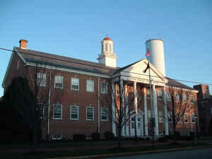
Salem County is a county located in the state of New Jersey. Based on the 2010 census, the county's population was 66,083. Its western
boundary is formed by the Delaware River and it has the eastern terminus of the Delaware Memorial Bridge, connecting to New Castle, Delaware.
Its county seat is Salem.
The county is part of the Delaware Valley area.
Etymology - Origin of Salem County Name
Salem is named for the Hebrew word for peace.
Demographics:
County QuickFacts: CensusBureau Quick Facts
Salem County History
European settlement began with English colonists in the seventeenth century, who were settling both sides of the
Delaware River. They established a colonial court in the area in 1681, but Salem County was first formally organized within West Jersey on May
17, 1694, from the Salem Tenth. Pittsgrove Township was transferred to Cumberland County in April 1867, but was restored to Salem County in
February 1868. The area was initially settled by Quakers.
The Old Salem County Courthouse, situated on the same block as the Salem County Courthouse, serves as the court for Salem City in the 21st
century. It is the oldest active courthouse in New Jersey and is the second oldest courthouse in continuous use in the United States, the
oldest being King William County Courthouse in Virginia. The courthouse was built in 1735 during the reign of King George II using locally
manufactured bricks. The building was enlarged in 1817 and additionally enlarged and remodeled in 1908. Its distinctive bell tower is
essentially unchanged and the original bell sits in the courtroom.
Judge William Hancock of the King's Court presided at the courthouse. He was later killed by the British in the American Revolutionary War
during the massacre at Hancock House committed by the British against local militia during the Salem Raid in 1778. Afterward the courthouse
was the site of the "treason trials," wherein suspected Loyalists were put on trial for having allegedly aided the British during the Salem
Raid. Four men were convicted and sentenced to death for treason; however, they were pardoned by Governor William Livingston and exiled from
New Jersey. The courthouse is also the site of the legend of Colonel Robert Gibbon Johnson's proving the edibility of the tomato. Before 1820,
Americans often assumed tomatoes were poisonous. In 1820, Colonel Johnson, according to legend, stood upon the courthouse steps and ate
tomatoes in front of a large crowd assembled to watch him do so.
Geography: Land and Water
According to the 2010 Census, the county had a total area of 372.33 square miles (964.3 km2), including 331.90 square miles (859.6 km2) of
land (89.1%) and 40.43 square miles (104.7 km2) of water (10.9%). The county is bordered on the west by the Delaware River, and drained by
Salem River, Alloway, and other creeks.
The terrain is almost uniformly flat coastal plain, with minimal relief. The highest elevation in the county has never been determined with
any specificity, but is likely one of seven low rises in Upper Pittsgrove Township that reach approximately 160 feet (49 m) in elevation. Sea
level is the lowest point.
Neighboring Counties
Bordering counties are as follows:
- Gloucester County, New Jersey - northeast
- Cumberland County, New Jersey - southeast
- Kent County, Delaware- southwest1
- New Castle County, Delaware - west
1across Delaware Bay; no land border
Education


Click Image to Enlarge
