


Click Image to Enlarge
Oklahoma Counties
There are seventy-seven counties in Oklahoma. Oklahoma originally had seven counties when it was first organized as the Oklahoma Territory. These counties were designated numerically, first through seventh. New counties added after this were designated by letters of the alphabet. The first seven counties were later renamed. The Oklahoma Constitutional Convention named all of the counties that were formed when Oklahoma entered statehood in 1907. Only two counties have been formed since thenBeckham County, Oklahoma
Beckham County Education, Geography, and History
Beckham County is a county located on the western border of the state of Oklahoma. Based on the 2010 census, the population was 22,119. Its
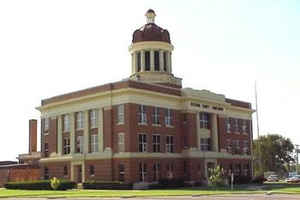
county seat is Sayre. Founded upon statehood in 1907, Beckham County was named for J. C. W. Beckham, who was Governor of Kentucky and the
first popularly elected member of the United States Senate from Kentucky. Beckham County comprises the Elk City, OK Micropolitan Statistical
Area.
(Beckham County, Kentucky was organized and named on February 9, 1904, but was dissolved April 29, 1904, by the Kentucky Court of Appeals
because it was not created in conformance with state law).
Etymology - Origin of Beckham County Name
Named by the Constitutional Convention for Hon. J. C. W. Beckham of Kentucky, former governor and U. S. Senator from that state, at the instance of a native of Kentucky who was a delegate in the Constitutional Convention.
Demographics:
County QuickFacts: CensusBureau Quick Facts
Beckham County History
In 1855, the US government leased the western part of the formerly reserved Choctaw and Chickasaw Nation lands,
which became known as the Leased District. After the Civil War, the two nations were forced to cede the land to the US government under terms
of new treaties required because they had been allies of the Confederacy. Under the treaties they were also required to emancipate their
slaves and provide them with citizenship in their nations.
In 1869, the former Leased District was designated by the President as the Cheyenne Arapaho Reservation, following their removal from further
west. During the 1880s, Texas cattlemen leased grazing land from the Cheyenne and Arapaho.
Under the Dawes Act of 1891, the government split up such communal lands, allocating plots to individual households of various tribes. After
distribution was made, the government declared any additional lands on the reservation to be "surplus". In 1892, the government opened such
surplus land to settlement by non-Indians, attracting numerous European-American settlers and immigrants.
The area was designated as County F in the newly created Oklahoma Territory, until it was renamed Roger Mills County. At statehood, portions
of land from both Roger Mills and Greer counties were joined to form Beckham County. Sayre was named as the temporary county seat. A 1908
election after statehood made Sayre, Oklahoma the permanent seat.
In 1910, a piece of southern Beckham County was returned to Greer County. The Gannett survey of 1927-1929 found that the true 100th Meridian,
the boundary between Texas and western Oklahoma, was 3,800 feet (1,200 m) farther east than previously thought. The US Supreme Court ruled
that the strip of land must be returned to Texas, thereby reducing Beckham County's area slightly.
Oklahoma History Center
Established at 1907 statehood, Beckham County is situated in southwestern Oklahoma. It was formed from the northern
portion of Greer County and the southern portion of Roger Mills County. Named in honor of Gov. John C. Beckham of
Kentucky, the county is bordered by Roger Mills County on the north, Custer and Washita counties on the east, Greer and
Harmon counties on the south, and Wheeler and Collingsworth counties, Texas, on the west. The county is drained by the
North Fork of the Red River. Among the numerous tributaries that flow into the North Fork are the Timber, Sweetwater,
and Buffalo creeks. The northwestern corner of the county lies within the High Plains, while the remainder of the county
lies in the Gypsum Hills physiographic region....BECKHAM
COUNTY
Geography: Land and Water
As reported by the Census Bureau, the county has a total area of 904 square miles (2,340 km2), of which 902 square miles (2,340 km2) is land and 2.1 square miles (5.4 km2) (0.2%) is water. The county is drained by the North Fork of the Red River and its tributaries: the Timber, Sweetwater, and Buffalo creeks. The northwestern part of the county is part of the High Plains. The rest of the county is part of the Gypsum Hills physiographic region.
Neighboring Counties
Bordering counties are as follows:
- Roger Mills County (north)
- Custer County (northeast)
- Washita County (east)
- Kiowa County (southeast)
- Greer County (south)
- Harmon County (southwest)
- Collingsworth County, Texas (west)
- Wheeler County, Texas (northwest)
Education


Click Image to Enlarge
