


Oklahoma State Almanac: Facts and Figures
Quick Facts, Figures, and Overview of the State of Oklahoma
Oklahoma is one of the West South Central states of the US. It is the 28th most populous state in the US. The state consists of mountain ranges, prairie, mesas, and eastern forests. Most of the state of Oklahoma lies in the Great Plains and US Interior Highlands and is prone to rough and extreme weather.
Oklahoma is one of the six states on the Frontier Strip. It is bounded from various directions by the states of Arkansas, Missouri, Kansas, Colorado, New Mexico and Texas. Oklahoma's name was derived when Allen Wright combined two Choctaw words, "ukla" meaning person and "huma'" meaning red to form the word that first appears in a 1866 Choctaw treaty. Oklahoma means "red person."
Oil made Oklahoma a rich state, but natural-gas production has now surpassed it. Minerals produced in Oklahoma include helium, gypsum, zinc, cement, coal, copper, and silver. Oklahoma's rich plains produce bumper yields of wheat, as well as large crops of sorghum, hay, cotton, and peanuts. More than half of Oklahoma's annual farm receipts are contributed by livestock products, including cattle, dairy products, swine, and broilers.
Oklahoma Almanac: Facts on the State of Oklahoma |
|||
|---|---|---|---|
| Official Name | Oklahoma | ||
| Capital | Oklahoma City | ||
| Nicknames | Sooner State ...and more | ||
| Motto | Labor Omnia Vincit (Labor conquers all things) | ||
| Location Region |
35.46705 N, 097.51349 W Great Plains Southwestern |
||
| Constitution Ratified | 1907 | ||
| Statehood | November 16, 1907 46th state |
||
| Population | 3,751,351 (2010) 50.24 sq. mi. 27th |
||
| Largest City (by population) |
10 largest cities (2010 est.):Oklahoma City, 579,999; Tulsa, 391,906; Norman, 110,925; Lawton, 96,867; Broken Arrow, 98,850; Edmond, 81,405; Moore, 55,081; Midwest City, 54,371; Enid, 49,379; Stillwater, 45,688 | ||
| Bordering States | North: Colorado and Kansas East: Missouri and Arkansas South: Texas (Red River forms much of the Southern boundary) West: Texas and New Mexico |
||
| Major Industry | farming (wheat, cattle), oil, natural gas | ||
| Major Rivers | Arkansas River, Canadian River, Red River | ||
| Major Lakes | Lake Texoma, Eufaula Lake, Lake Hudson, Lake O' the Cherokees, Gibson Lake, Oologah Lake, Keystone Lake | ||
| Oklahoma Counties | 77 Counties in Oklahoma | ||
| Largest County (by population) |
Oklahoma County 718,633 (2010) 709 sq. mi. |
||
| Largest County (by area) |
Osage County 2,251 sq. mi. |
||
| State parks | 50 | ||
| Electoral Votes | 7 (as of the 2004 Presidential Election) | ||
| US Congress | 2 Senators; 5 Representatives | ||
| Time Zone | Central Standard Time | ||
| Zip Codes | NANPA | ||
| State Quick Facts | Census Bureau Quick Facts | ||
Oklahoma Climate and Weather |
|
|---|---|
| Weather conditions in Oklahoma vary widely.
Summers are usually hot, humid and windy, with cooler evenings. In winter, northern cold fronts and chilling winds bring temperatures down to freezing.
Early evening thunderstorms are common in summer, and tornados strike the state on a regular basis. Oklahoma is in America's Tornado Alley. January is the coldest month, with average high temperatures near 40 degrees. July is the warmest month, with average high temperatures around 82 degrees. Hotter summers and colder winters, with snow, are not uncommon. Annual precipitation amounts range from 20 - 30 inches central and west, while in the east, 40 - 50 inches are normal. |
|
| Highest Temperature | 120 degrees July 26, 1934 - Tishmoningo |
| Lowest Temperature | -27 degrees January 18, 1930 - Watts |
| Avg. Temp: High - Low |
93.9 degrees 24.8 degrees |
Oklahoma Points of Interest |
|
| Numerous American Indian historic sites and museums, State Capital Building and Murrah Federal Building monument in Oklahoma City, the Will Rogers Museum, National Cowboy Hall of Fame in Oklahoma City, the Will Rogers Memorial in Claremore, the Cherokee Cultural Center with a restored Cherokee village, the restored Fort Gibson Stockade near Muskogee, the Lake Texoma recreation area, pari-mutuel horse racing at Remington Park in Oklahoma City, and Blue Ribbon Downs in Sallisaw, and much, much more. | |
Oklahoma Highest, Lowest, and Mean Elevations (Feet) |
|
| Mean Elevation: 1,300 feet | |
|
Highest Point: Black Mesa: 4,973 feet
|
|
| Lowest Point: | Little River 289 feet |
Oklahoma Land Area (Square Miles) |
|
| Geographic Center | In Oklahoma County, 8 mi. N of Oklahoma City Longitude: 97°39.6'W Latitude: 35°32.2'N |
| Total Area | 69,898.19 sq. mi. 20th |
| Land Area | 68,667.06 sq. mi. 98.24% |
| Water Area | 1,231.13 sq. mi. 1.76% |
| Forested Land Area | 17.4% |
| Dimensions (Length - Width) |
400 miles - 220 miles |
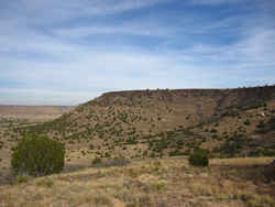 Located in Cimarron County, Oklahoma,
Black Mesa Nature Preserve consists of approximately 1,600 acres which the Conservancy has conveyed to the Oklahoma Tourism and Recreation Department
with a management agreement. The preserve protects about 60% of the mesa top in Oklahoma in addition to talus slopes and plains habitat. A native
granite monument marks the highest point in Oklahoma - 4,973 feet above sea level.
Located in Cimarron County, Oklahoma,
Black Mesa Nature Preserve consists of approximately 1,600 acres which the Conservancy has conveyed to the Oklahoma Tourism and Recreation Department
with a management agreement. The preserve protects about 60% of the mesa top in Oklahoma in addition to talus slopes and plains habitat. A native
granite monument marks the highest point in Oklahoma - 4,973 feet above sea level.Adair, Alfalfa, Atoka, Beaver, Beckham, Blaine, Bryan, Caddo, Canadian, Carter, Cherokee, Choctaw, Cimarron, Cleveland, Coal, Comanche, Cotton, Craig, Creek, Custer, Delaware, Dewey, Ellis, Garfield, Garvin, Grady, Grant, Greer, Harmon, Harper, Haskell, Hughes, Jackson, Jefferson, Johnston, Kay, Kingfisher, Kiowa, Latimer, LeFlore, Lincoln, Logan, Love, Major, Marshall, Mayes, McClain, McCurtain, McIntosh, Murray, Muskogee, Noble, Nowata, Okfuskee, Oklahoma, Okmulgee, Osage, Ottawa, Pawnee, Payne, Pittsburg, Pontotoc, Pottawatomie, Pushmataha, Roger Mills, Rogers, Seminole, Sequoyah, Stephens, Texas, Tillman, Tulsa, Wagoner, Washington, Washita, Woods, Woodward

