Oklahoma Counties
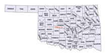
There are seventy-seven counties in Oklahoma. Oklahoma originally had seven counties when it was first organized as the Oklahoma Territory. These counties were designated numerically, first through seventh. New counties added after this were designated by letters of the alphabet. The first seven counties were later renamed. The Oklahoma Constitutional Convention named all of the counties that were formed when Oklahoma entered statehood in 1907. Only two counties have been formed since thenCuster County, Oklahoma
Custer County Education, Geography, and History

Custer County is a county located in the state of Oklahoma. Based on the 2010 census, the population was 27,469. Its county seat is Arapaho.
The county was named in honor of General George Armstrong Custer.
Custer County comprises the Weatherford, OK Micropolitan Statistical Area.
Etymology - Origin of Custer County Name
Named for Gen. George A. Custer.
Demographics:
County QuickFacts: CensusBureau Quick Facts
Custer County History
Custer County was formed on 1891 as an original county from Cheyenne land, and called G County. On November 6, 1896 it was renamed Custer County after General George Armstrong Custer, who had massacred the Southern Cheyenne Indians at the Battle of the Washita 20 miles west in Roger Mills County, and was killed at the Battle of Little Bighorn. The county was settled by white settlers during the third official land run of April 19, 1892. On this day the first newspaper of the county appeared, the Arapaho Arrow.
Oklahoma History Center
Following the Cheyenne-Arapaho Opening on April 19, 1892, Custer County came into existence as G County, with Arapaho
designated as the county seat. In a general election held in November 1896, G County became known as Custer, in honor of
Lt. Col. George A. Custer. Located in west-central Oklahoma, Custer County is bordered by Dewey County on the north,
Blaine and Caddo counties on the east, Washita County on the south, and Beckham and Roger Mills counties on the west.
The Canadian River flows across the northeastern corner of the county. Drained by the Washita River, Custer County has
1,002 square miles of land and water. It lies mostly within the Gypsum Hills physiographic region. At the turn of the
twenty-first century incorporated towns included Butler, Clinton, Custer City, Thomas, Weatherford, and Arapaho, the
county seat....CUSTER
COUNTY
Geography: Land and Water
As reported by the Census Bureau, the county has a total area of 1,002 square miles (2,600 km2), of which 989 square miles (2,560 km2) is land and 13 square miles (34 km2) (1.3%) is water.
Neighboring Counties
Bordering counties are as follows:
- Dewey County (north)
- Blaine County (east)
- Caddo County (southeast)
- Washita County (south)
- Beckham County (southwest)
- Roger Mills County (west)


