


Click Image to Enlarge
Oklahoma Counties
There are seventy-seven counties in Oklahoma. Oklahoma originally had seven counties when it was first organized as the Oklahoma Territory. These counties were designated numerically, first through seventh. New counties added after this were designated by letters of the alphabet. The first seven counties were later renamed. The Oklahoma Constitutional Convention named all of the counties that were formed when Oklahoma entered statehood in 1907. Only two counties have been formed since thenDelaware County, Oklahoma
Delaware County Education, Geography, and History
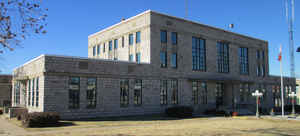
Delaware County is a county located in the state of Oklahoma. Based on the 2010 census, the population was 41,487. Its county seat is
Jay. The county was named for the Delaware Indians who had established a village in the area prior to the arrival of the Cherokees in Indian
Territory in the 1830s.
Delaware County was created in 1907. Prior to becoming Delaware County, a large portion of the area was known as the Delaware District of the
Cherokee Nation. Today, Delaware County continues to be recognized by the Cherokee Nation as the Delaware District.
Etymology - Origin of Delaware County Name
Named for Delaware District of the old Cherokee Nation. Delaware District took its name from Delaware Town which was located in the Spavinaw Hills in the early part of the last century. It was occupied by a band of Delaware Indians who left the United States and settled in Louisiana Province, then Spanish territory, shortly after the close of the American Revolution.
Demographics:
County QuickFacts: CensusBureau Quick Facts
Delaware County History
Archaeological studies have shown that at least three different periods of prehistoric people had lived in the area
covered by Delaware County. These included 23 Archaic, 17 Woodland, and 63 Eastern Villager sites. Artifacts date back between 1400 and 2000
years from the present. Many of these sites have been submerged since the creation of Grand Lake o' the Cherokees.
Few Native Americans lived in the area until the early nineteenth century, when the federal government began relocating tribes from the
Eastern United States. About 1820, a group of Delaware, who had allied with the Cherokee against the Osage, settled Delaware Town, about two
miles south of the present town of Eucha. In 1828, the Western Cherokee moved from Arkansas Territory into the area just south of the present
Delaware County. In 1832, the Seneca moved from Ohio into an area that included the northeastern part of Delaware County.
The present day county was created at statehood in 1907. Initially, Grove, the only incorporated town in the county, was designated as the
county seat. However, a large number of county residents wanted a more centrally located seat. This group founded the town of Jay, where they
built a wooden courthouse and won an election to move the county seat. A court suit resolved the dispute in favor of the Jay location.
Oklahoma History Center
Located in northeastern Oklahoma, Delaware County is bordered on the east by McDonald County, Missouri, and Benton
County, Arkansas, on the south by Adair and Cherokee counties, on the west by Mayes and Craig counties, and on the north
by Ottawa County. US Highway 59 crosses the region north and south. The Cherokee Turnpike, also US Highway 412,
crosses the southern end of Delaware County. Other important routes include State Highways 10, 20, 28, 85, 116, 125, and
127. The county lies on the western slopes of the Ozark Plateau, an area of forests, prairies, and farm land. The Grand
River and Elk River are the major water courses in the county's northern portion, while Flint Creek and the Illinois
River drain in the southern part. The Ozark limestone holds no oil nor any minerals but provides an abundant supply of
water. The county's total land and water area is 792.33 square miles....DELAWARE
COUNTY
Geography: Land and Water
As reported by the Census Bureau, the county has a total area of 792 square miles (2,050 km2), of which 738 square miles
(1,910 km2) is land and 54 square miles (140 km2) (6.8%) is water.
The county lies on the western slope of the Ozark Plateau. There are no oil, gas or mineral resources of economic consequence, but the county
has abundant water.
Lake Eucha, a man-made reservoir on Spavinaw Creek, completed in 1952, lies primarily within Delaware County. Grand Lake o' the Cherokees,
completed in 1940, and Lake Spavinaw, completed in 1924, are partly within Delaware County. The Grand River and the Elk River drain the
northern part of the county, while Flint Creek and the Illinois River drain the southern part.
Neighboring Counties
Bordering counties are as follows:
- Ottawa County (north)
- McDonald County, Missouri northeast)
- Benton County, Arkansas (east)
- Adair County (south)
- Cherokee County (south)
- Mayes County (west)
- Craig County (northwest)
Education


Click Image to Enlarge
