


Click Image to Enlarge
Oklahoma Counties
There are seventy-seven counties in Oklahoma. Oklahoma originally had seven counties when it was first organized as the Oklahoma Territory. These counties were designated numerically, first through seventh. New counties added after this were designated by letters of the alphabet. The first seven counties were later renamed. The Oklahoma Constitutional Convention named all of the counties that were formed when Oklahoma entered statehood in 1907. Only two counties have been formed since thenDewey County, Oklahoma
Dewey County Education, Geography, and History
Dewey County is a county in the western part of the state of Oklahoma. Based on the 2010 census, the population was 4,810. Its county seat is Taloga. The county was created in 1891 as "County D". In an 1898 election, county voters chose the name Dewey, honoring Admiral George Dewey
Etymology - Origin of Dewey County Name
was designated as county "D" at the time of the opening of the Cherokee-Arapaho Reservation in 1892 and continued to be known as County "D" until the general election of 1898 when the people of the county voted that "D" had stood for Dewey throughout all these years.
Demographics:
County QuickFacts: CensusBureau Quick Facts
Dewey County History
Lands assigned to the Choctaw and Seminole tribes extended into the area now occupied by Dewey County. Under the
Reconstruction Treaties of 1866 the Choctaw and Chickasaw ceded their western domain to the United States. Known as the Leased District, part
of the area became the Cheyenne and Arapaho reservation.
Dewey County was created in Oklahoma Territory in 1891 and was opened to non-Indian settlement on April 19, 1892. It was then named as County
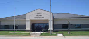
D by an act of Congress, and did not receive its present name until a general election in 1898. A wooden structure in Taloga was used as the
county courthouse from 1909 until 1926, when the present courthouse was built.
Oklahoma History Center
Located in west-central Oklahoma, Dewey County is bordered by Woodward and Major counties on the north, Blaine County
on the east, Custer County on the south, and Ellis and Roger Mills counties on the west. Named for Adm. George Dewey,
the county was formerly part of the Cheyenne-Arapaho Reservation. Dewey County is comprised of 1,008.26 square miles of
land and water. Drained by the Canadian and North Canadian rivers it lies mostly in the Gypsum Hills physiographic
region. The western one-fourth of the county is situated in the High Plains region. At the turn of the twenty-first
century incorporated towns included Camargo, Leedey, Oakwood, Putnam, Seiling, Vici, and Taloga, the county seat.....DEWEY
COUNTY
Geography: Land and Water
As reported by the Census Bureau, the county has a total area of 1,008 square miles (2,610 km2), of which 999 square miles
(2,590 km2) is land and 8.8 square miles (23 km2) (0.9%) is water.
Most of the county is in the Gypsum Hills physiographic region, except that the western one-fourth of the county is in the High Plains region.
It is drained by the Canadian and North Canadian Rivers. Canton Lake, built on the Canadian River in 1966, is the only significant lake or
reservoir in the county.
Neighboring Counties
Bordering counties are as follows:
- Woodward County (north)
- Major County (north)
- Blaine County (east)
- Custer County (south)
- Roger Mills County (southwest)
- Ellis County (northwest)
Education


Click Image to Enlarge
