


Click Image to Enlarge
Oklahoma Counties
There are seventy-seven counties in Oklahoma. Oklahoma originally had seven counties when it was first organized as the Oklahoma Territory. These counties were designated numerically, first through seventh. New counties added after this were designated by letters of the alphabet. The first seven counties were later renamed. The Oklahoma Constitutional Convention named all of the counties that were formed when Oklahoma entered statehood in 1907. Only two counties have been formed since thenOklahoma County, Oklahoma
Oklahoma County Education, Geography, and History
Oklahoma County is a county located in the central part of the state of Oklahoma. Based on the 2010 census, the population was 718,633,
making it the most populous county in Oklahoma. The county seat is Oklahoma City, the state capital.
Oklahoma County is at the heart of the Oklahoma City Metropolitan Statistical Area.
Oklahoma County is one of seven counties in the United States to share the same name as the state it is located in (the other six counties are
Arkansas County, Hawaii County, Idaho County, Iowa County, New York County, and Utah County)
Etymology - Origin of Oklahoma County Name
combination of two Choctaw words "Okla" meaning people and "Humma" red.
Demographics:
County QuickFacts: CensusBureau Quick Facts
Oklahoma County History
Oklahoma County was originally called County Two and was one of seven counties established by the Organic Act of
1890.
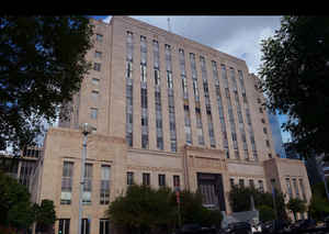
County business initially took place in a building at the intersection of California Avenue and Robinson Street until the construction of the
first Oklahoma County Courthouse at 520 West Main Street in the 1900s. In 1937, the county government was moved to a building at 321 Park
Avenue, which now serves only as the county courthouse.
Oklahoma History Center
Located in central Oklahoma, Oklahoma County is bordered by Logan County on the north, Lincoln and Pottawatomie
counties on the east, Cleveland County on the south, and Canadian County on the west. Formed from the Unassigned Lands
and designated as County Two in 1890, Oklahoma County is drained by the Deep Fork and the North Canadian rivers. Named
for Oklahoma City the county is comprised of 718.31 acres of land and water and is located in the Red Bed Plains
physiographic region. At the turn of the twenty-first century incorporated towns included Arcadia, Bethany, Choctaw, Del
City, Edmond, Forest Park, Harrah, Jones, Lake Aluma, Luther, Midwest City, Nichols Hills, Nicoma Park, Smith Village,
Spencer, Valley Brook, The Village, Warr Acres, Woodlawn Park, and Oklahoma City, the county seat and state capital....OKLAHOMA
COUNTY
Geography: Land and Water
As reported by the Census Bureau, the county has a total area of 718 square miles (1,860 km2), of which 709 square miles (1,840 km2) is land and 9.6 square miles (25 km2) (1.3%) is water.
Neighboring Counties
Bordering counties are as follows:
- Logan County (north)
- Lincoln County (east)
- Pottawatomie County (southeast)
- Cleveland County (south)
- Canadian County (west)
- Kingfisher County (northwest)
Education


Click Image to Enlarge
