


Click Image to Enlarge
Oklahoma Counties
There are seventy-seven counties in Oklahoma. Oklahoma originally had seven counties when it was first organized as the Oklahoma Territory. These counties were designated numerically, first through seventh. New counties added after this were designated by letters of the alphabet. The first seven counties were later renamed. The Oklahoma Constitutional Convention named all of the counties that were formed when Oklahoma entered statehood in 1907. Only two counties have been formed since thenOkmulgee County, Oklahoma
Okmulgee County Education, Geography, and History
Okmulgee County is a county located in the state of Oklahoma. Based on the 2010 census, the population was 40,069. The county seat is
Okmulgee. Formerly part of the Creek Nation, the county was created at statehood in 1907. The name Okmulgee is derived from the Hitichita
(Lower Creek) word okimulgi, meaning "boiling waters".
Okmulgee County is included in the Tulsa, OK Metropolitan Statistical Area.
Etymology - Origin of Okmulgee County Name
Named for its county seat town which, in turn, was named for one of the old Creek towns or clans.
Demographics:
County QuickFacts: CensusBureau Quick Facts
Okmulgee County History
The Creek Nation moved into this part of Indian Territory after signing treaties exchanging their land in Georgia
and Alabama in 1826 and 1832. The actual move occurred over the period from 1827 to 1836. The Creek Nation government, led by chief Samuel
Checote, revised its constitution in 1867 and designated Okmulgee as its capital in 1868. The US Post Office opened in Okmulgee on April 29,
1869. The Creek Nation built its council house in Okmulgee, a log building, in 1869. The building was rebuilt of stone in 1878.
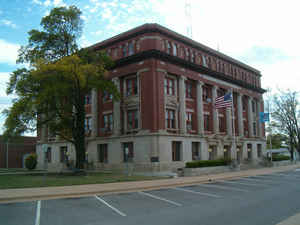
Okmulgee County was formed on July 16, 1907, from Muskogee land, with a population of 14,362. County government offices were located in the
Creek Council House until 1916, when the present Okmulgee County Courthouse was built. Since then, the former council building has been used
as a Muscogee Creek history museum.
Oklahoma History Center
Located in east-central Oklahoma, Okmulgee County is encircled by Creek County to the west-northwest, Tulsa County on
the north, Wagoner County to the northeast, Muskogee County on the east, McIntosh County to the south-southeast, and
Okfuskee County on the south-southwest. The county has a total of 702.30 square miles of land and water area. Eastern
Okmulgee County lies within the Eastern Lowlands physiographic region and the western part is in the Osage Plains. Deep
Fork of the Canadian River and its tributaries are its major stream system. Interstate 40, US Highways 62, 75, 75 ALT,
and 266, and State Highways 16, 52, and 56 traverse the county. At the turn of the twenty-first century its incorporated
communities included Okmulgee (the county seat), Morris, Henryetta, Beggs, Grayson, Hoffman, Dewar, and Winchester....OKMULGEE
COUNTY
Geography: Land and Water
As reported by the Census Bureau, the county has a total area of 702 square miles (1,820 km2), of which 697 square miles
(1,810 km2) is land and 5.0 square miles (13 km2) (0.7%) is water.
Okmulgee Lake and Okmulgee State Park lies southwest of the city of Okmulgee. The eastern part of the county is within the Eastern Lowlands
physiographic region and the western part is in the Osage Plains. The Deep Fork of the Canadian River is the principal waterway in the county.
Deep Fork National Wildlife Refuge lies within the county.
Neighboring Counties
Bordering counties are as follows:
- Tulsa County (north)
- Wagoner County (northeast)
- Muskogee County (east)
- McIntosh County (southeast)
- Okfuskee County (southwest)
- Creek County (northwest)
Education


Click Image to Enlarge
