


Click Image to Enlarge
Oklahoma Counties
There are seventy-seven counties in Oklahoma. Oklahoma originally had seven counties when it was first organized as the Oklahoma Territory. These counties were designated numerically, first through seventh. New counties added after this were designated by letters of the alphabet. The first seven counties were later renamed. The Oklahoma Constitutional Convention named all of the counties that were formed when Oklahoma entered statehood in 1907. Only two counties have been formed since thenOsage County, Oklahoma
Osage County Education, Geography, and History
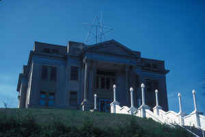
Osage County is a county in the northern part of the state of Oklahoma. Based on the 2010 census, the population was 47,472. Its county seat
is Pawhuska.
Osage County is included in the Tulsa, OK Metropolitan Statistical Area.
Etymology - Origin of Osage County Name
the tribal name "Wazhazhe," as spelled by the French settlers of the Mississippi Valley.
Demographics:
County QuickFacts: CensusBureau Quick Facts
Osage County History
By the 17th century, the Osage and other Siouan tribes had been forced to move west from the Ohio Valley across the
Mississippi River. The Osage became established as a powerful nation in the areas of present-day Missouri and Arkansas between the Missouri
River and Red rivers, as well as extending to the west. By 1760, they had increased their range to include the present Osage County.
Historically one of the most powerful Great Plains tribes, their numbers were reduced by infectious disease and warfare after encounter with
Europeans.
In 1825, they ceded their claim to the land in present-day Oklahoma to the United States government, which included it in a "perpetual outlet
to the west given to the Cherokee Nation by the Treaty of New Echota" in 1835. This treaty was to accomplish Cherokee removal to the Indian
Territory. During the American Civil War, on December 26, 1861, a band of pro-Union Creek and Seminole fought with a Confederate Army unit at
the Battle of Chustenahlah on Bird Creek, near the present town of Skiatook. Generally the Five Civilized Tribes were allied with the
Confederacy.
In 1870, the Osage finally prepared for removal from Kansas, after having negotiated payment for their land. They purchased 1.57 million acres
(6,400 km2) of their former territory in present-day Oklahoma from the Cherokee. By owning it, they had a stronger position in relation to the
US government than did other tribes. The Osage Agency was established in 1872 at Deep Ford, later renamed as Pawhuska. It was designated as
the county seat when Oklahoma was admitted as a state. The other chief settlements in the 1870s were Hominy and Fairfax; each of the three was
settled by a major Osage band.
In 1875 the US designated their land as the Osage Reservation. Because the tribe owned the land directly, they retained more control over
their affairs than did tribes who only had rights to land held "in trust" by the United States government. This reservation became part of the
Oklahoma Territory under the Oklahoma Organic Act of 1890. It became a semi-autonomous district by the Oklahoma Enabling Act of 1906, and
Osage County at the time of Oklahoma Statehood in 1907. At that time, there were 2,229 registered Osage members.
Oklahoma History Center
Oklahoma's largest county by area, Osage County is located in the north-central part of the state and contains a
total land and water area of 2,303.8 square miles. Created at 1907 statehood the county was named for and is home to the
Osage tribe and is contiguous with the Osage Nation Reservation. It is surrounded by Washington County on the east,
Tulsa County on the east and south, Pawnee County on the south, Noble and Kay counties on the west, and the state of
Kansas on the north. Pawhuska is the county seat, and Avant, Barnsdall, Burbank, Fairfax, Foraker, Grainola, Hominy,
Osage, Prue, Shidler, Webb City, and Wynona are other incorporated towns. US Highway 60 runs east-west through the
county, and state highways include 10, 11, 18, 20, 35, 97, 99, and 123.
Most of Osage County lies in the Osage Plains physiographic region and is characterized by open and rolling prairie. The
extreme east-northeastern area of the county is in the Eastern Lowlands region. Eastern Osage County has the Osage
Hills, an extension of the Flint Hills of Kansas. Gray Horse, Salt, and Drum creeks drain the county's western and
southern sections. These streams flow south into the Arkansas River, which serves as part of the county's southern and
western boundaries. Eastern Osage County is drained by the Caney River and Bird, Hominy, and Delaware creeks, which flow
east to the Verdigris River. County reservoirs include Lakes Keystone and Kaw, which were impounded on the Arkansas
River as well as Hulah, Birch, Bluestem, and Skiatook lakes....OSAGE
COUNTY
Geography: Land and Water
As reported by the Census Bureau, the county has a total area of 2,304 square miles (5,970 km2), of which 2,246 square miles
(5,820 km2) is land and 58 square miles (150 km2) (2.5%) is water. It is the largest county in Oklahoma by area. Most of the county is in the
Osage Plains, and consists of open prairie. The eastern part of the county contains the Osage Hills, an extension of the Flint Hills in
Kansas. Tallgrass Prairie Preserve is north of Pawhuska.
Holmes Peak is a mountain northwest of Tulsa in Osage County. It was named by the United States Board on Geographic Names on October 5, 1983
for the fictional detective, Sherlock Holmes. The name was proposed by Richard S. Warner. Holmes Peak is the highest point in the Tulsa
Metropolitan area, with an elevation of 1,030 feet (310 m), though it ranks only as the 379th highest point in the state.
Gray Horse Creek, Drum Creek and Salt Creek all drain the southwestern part of the county and flow into the Arkansas River, which is part of
the county's southern and western boundaries. Eastern Osage County drains into Caney River, Bird Creek, Hominy Creek, and Delaware Creek. All
of these streams flow into the Verdigris River.
Lakes and reservoirs in the county include:
Birch Lake
Bluestem Lake
Hulah Lake (Oklahoma)
Kaw Lake
Keystone Lake
Skiat Lake
Neighboring Counties
Bordering counties are as follows:
- Cowley County, Kansas (northwest)
- Chautauqua County, Kansas (north)
- Washington County (east)
- Tulsa County (southeast)
- Pawnee County (southwest)
- Kay County (west)
- Noble County (west)
Education


Click Image to Enlarge
