Oklahoma Counties
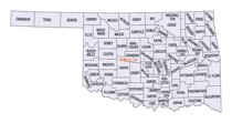
There are seventy-seven counties in Oklahoma. Oklahoma originally had seven counties when it was first organized as the Oklahoma Territory. These counties were designated numerically, first through seventh. New counties added after this were designated by letters of the alphabet. The first seven counties were later renamed. The Oklahoma Constitutional Convention named all of the counties that were formed when Oklahoma entered statehood in 1907. Only two counties have been formed since thenPayne County, Oklahoma
Payne County Education, Geography, and History

Payne County is a county in the state of Oklahoma. Based on the 2010 census, the population was 77,350. Its county seat is Stillwater. The
county was created in 1890 as part of Oklahoma Territory and is named for Capt. David L. Payne, a leader of the "Boomers".
Payne County comprises the Stillwater, OK Micropolitan Statistical Area. The county lies northeast of the Oklahoma City metropolitan area
though many consider it an extension of the Oklahoma City metro area due to commuter patterns and other indicators.
Etymology - Origin of Payne County Name
Named for Captain David L. Payne, the leader of the "boomers" who tried to settle in Oklahoma before its settlement was authorized by Congress.
Demographics:
County QuickFacts: CensusBureau Quick Facts
Payne County History
This county was established and named as the Sixth County by the Oklahoma Organic Act of 1890. It included land settled during the Land Run of 1889. The Organic Act settled a dispute between the towns of Stillwater and Perkins over which should be the county seat.
Oklahoma History Center
Created on land that was once part of the Creek Nation, Payne was one of the first counties established in Oklahoma
Territory by the Organic Act in May 1890. It was first designated as the Sixth County, but was later named to honor
Boomer leader David L. Payne. The county was part of the territory settled during the Land Run of 1889.
Payne County's topography of rolling plains lies mostly within the Sandstone Hills physiographic region, and the western
part of the county lies within the Red Bed Plains. The Twin Mounds, limestone-topped hills lying east of Ingalls, is the
most noticeable feature. The Cimarron River is the primary waterway, draining most of the county via its own smaller
tributaries and Stillwater Creek and its tributaries. Prehistoric occupation of the region has been revealed in various
archaeological sites in the county, including four of the Archaic period (6000 B.C. to A.D.1), two Woodland sites (A.D.
1 to 1000), and two Plains Village sites (A.D. 1000 to 1500)....PAYNE
COUNTY
Geography: Land and Water
As reported by the Census Bureau, the county has a total area of 697 square miles (1,810 km2), of which 685 square miles
(1,770 km2) is land and 12 square miles (31 km2) (1.8%) is water.
Payne County is covered by rolling plains, mostly within the Sandstone Hills physiographic region, but with the western part of the county in
the Red Bed plains. The county has two significant reservoirs: McMurtry Lake and Carl Blackwell Lake. The Cimarron River and Stillwater Creek
drain most of the county.
Neighboring Counties
Bordering counties are as follows:
- Noble County (northwest)
- Pawnee County (northeast)
- Creek County (east)
- Lincoln County (south)
- Logan County (southwest)
Education
Educational entities located in Payne County include:
Oklahoma Department of Career and Technology Education
Oklahoma State University-Stillwater
Northern Oklahoma College


