


Click Image to Enlarge
Oklahoma Counties
There are seventy-seven counties in Oklahoma. Oklahoma originally had seven counties when it was first organized as the Oklahoma Territory. These counties were designated numerically, first through seventh. New counties added after this were designated by letters of the alphabet. The first seven counties were later renamed. The Oklahoma Constitutional Convention named all of the counties that were formed when Oklahoma entered statehood in 1907. Only two counties have been formed since thenStephens County, Oklahoma
Stephens County Education, Geography, and History
Stephens County is a county located in the state of Oklahoma. Based on the 2010 census, the population was 45,048. Its county seat is
Duncan. The county was created at statehood, partly from the Chickasaw Nation in Indian Territory and partly from Comanche County in Oklahoma
Territory. It was named for Texas politician John Hall Stephens.
Stephens County comprises the Duncan, OK Micropolitan Statistical Area.
Etymology - Origin of Stephens County Name
Named for John H. Stephens, congressman from Texas, who took great interest in Indian Territory legislation just prior to statehood.
Demographics:
County QuickFacts: CensusBureau Quick Facts
Stephens County History
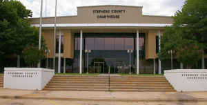
Stephens County was created at statehood from portions of both Oklahoma Territory (OT) and Indian Territory (IT). About two-thirds of the area came from Pickens County, Chickasaw Nation, IT, and the western third came from Comanche County, OT. The town of Duncan was designated as the county seat. County offices were located in rented facilities in Duncan until the first courthouse was built in 1921. That building was replaced by a new facility in 1967.
Oklahoma History Center
Located in south-central Oklahoma Stephens County is bordered by Comanche, Grady, and Garvin counties on the north,
Garvin and Carter counties on the east, Jefferson County on the south, and Comanche and Cotton counties on the west.
Named for Texas politician John H. Stephens, the county was organized at 1907 statehood from part of the Chickasaw
Nation, Indian Territory, and part of Comanche County, Oklahoma Territory. Comprised of 891.12 squares miles of land and
water, Stephens County lies within the Red Bed Plains physiographic region. The county has no major river but is drained
by numerous creeks. The Wildhorse Creek in eastern Stephens County drains into the Washita River, and Beaver Creek in
the western part of the county flows into the Red River. At the turn of the twenty-first century incorporated towns
included Bray, Central High, Comanche, Empire City, Loco, Marlow, Velma, and Duncan, the county seat....STEPHENS
COUNTY
Geography: Land and Water
As reported by the Census Bureau, the county has a total area of 891 square miles (2,310 km2), of which 870 square miles (2,300 km2) is land and 21 square miles (54 km2) (2.4%) is water. It lies within the Red Bed plains. Although there is no major river in the county, there are some creeks that provide drainage. Wildhorse Creek in the eastern part flows into the Washita River. Beaver Creek in the western part of the county flows into the Red River. Lakes in the county include Lake Humphreys, Clear Creek Lake, Duncan Lake, Comanche Lake, and Waurika Lake.
Neighboring Counties
Bordering counties are as follows:
- Grady County (north)
- Garvin County (northeast)
- Carter County (southeast)
- Jefferson County (south)
- Cotton County (southwest)
- Comanche County (northwest)
Education


Click Image to Enlarge
