


Click Image to Enlarge
Wisconsin Counties
There are seventy-two counties in the state of Wisconsin. Wisconsin became part of the Territory of Michigan and divided into two counties: Brown County in the northeast along Lake Michigan and Crawford County in the southwest along the Mississippi River. The state of Wisconsin was created from Wisconsin Territory on May 29, 1848, with 28 counties.Calumet County, Wisconsin
Calumet County Education, Geography, and History
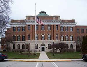
Calumet County is a county located in the state of Wisconsin. Based on the 2010 census, the population was 48,971. The county seat is
Chilton. The county was created in 1836 (then in the Wisconsin Territory) and organized in 1850.
Calumet County is included in the Appleton, WI Metropolitan Statistical Area as well as the Appleton-Oshkosh-Neenah, WI Combined Statistical
Area.
Etymology - Origin of Calumet County Name
Calumet County was named for a Menominee Indian village situated on the southeast shore of Lake Winnebago; see Wis. Hist. Colls., vi, p. 171; F. W. Hodge, "Handbook of American Indians," in S. Bureau of Ethnology Bulletin No. 30, p. 195. The origin of the word is the Norman-French form of chalumet, a tube or reed, which was applied by French Canadians to the Indian implement known as "the pipe of peace" (Gannett, Place Names, p. 59; Handbook, p. 191).
Demographics:
County QuickFacts: CensusBureau Quick Facts
Calumet County History
John W. Hunt's 1853 Wisconsin Gazetteer:
"CALUMET, County, is bounded on the north by Brown and Outagamie, on the east by Manitowoc, on the south by Sheboygan and Fond du Lac, and on the west by Winnebago. It was set off from Brown, December 7, 1836, and organized for county purposes, January 6, 1840. It is well watered by tributaries of the Manitowoc river, and by small streams entering Lake Winnebago. The Brothertown and Stockbridge Indians have fine settlements, schools, and churches, in this county, and their farms and buildings compare favorably with others in the State. They are entitled to all the privileges of citizenship, and are frequently represented by some of their own number in the State legislature. This county contains much good land, which is for sale at low rates; the soil is good, and covered with a heavy growth of hard timber. The population in 1840 was 275; 1842, 407; 1846, 836; 1847, 1,060; 1850, 1,746. Farms, 243; manufactories, 5; dwellings, 381."
[Source: Kellogg, Louise Phelps. "Derivation of County Names" in Proceedings of the State Historical Society of Wisconsin for 1909, pages 219-231. ]
CALUMET.--Population 3,633.
From: Handbook of Wisconsin by S. Silas, 1855
pg. 51-52
Lies on the cast shore of Lake Winnebago, and is yet but slightly settled compared with its surrounding
neighbors. It is covered with a heavy growth of hard timber, and contains what was for a long time the Stockbridge
Indian Reservation. These two causes, kept the settlers from this county until Winnebago, on the west side of the
Lake, with the attractions of timber, openings and prairies had so far out-stripped Calumet in population that there
is little prospect of its reaching that degree of prosperity which its neighbors have acquired. There are still the
remains of the Stockbridge and Brothertown Indians in the County occupying their well tilled farms. The County is
well watered, and contains much excellent land yet unoccupied.
Within a few months Calumet has advanced more rapidly in population, than at any previous period. In 1850 the
population, including about 300 Indians, was 1740, in 1855 exclusive of the same, it was 3,531.
Chilton Centre, a flourishing village in the County Seat.
This County is wholly in the Green Bay land district, and entries must be made at the land offices at Menasha.
Geography: Land and Water
As reported by the Census Bureau, the county has a total area of 1,041 square miles (2,697 km2), of which, 1,010 square miles (2,617 km2) of it is land and 31 square miles (80 km2) of it (2.97%) is water.
Neighboring Counties
Bordering counties are as follows:
- Brown County - northeast
- Manitowoc County - east
- Sheboygan County - southeast
- Fond du Lac County - southwest
- Winnebago County - west
- Outagamie County - northwest
Education


Click Image to Enlarge
