


Wisconsin State Almanac: Facts and Figures
Quick Facts, Figures, and Overview of the State of Wisconsin

Wisconsin is one of the East North Central states of the US. The state shares its boundaries with Iowa, Minnesota, Illinois, Michigan, Lake Michigan, and Lake Superior. Wisconsin is the 30th state in the United States. The capital of the state is Madison and the biggest city is Milwaukee. An Indian name, spelled Ouisconsin and Mesconsing by early chroniclers. Believed to mean "grassy place" in Chippewa. Congress made it name, Wisconsin.
Wisconsin is a leading state in milk and cheese production. Other important farm products are peas, beans, beets, corn, potatoes, oats, hay, and cranberries.
The chief industrial products of the state are automobiles, machinery, furniture, paper, beer, and processed foods. Wisconsin ranks first among the
paper-producing states. The state's mines produce copper, iron ore, lead, and zinc.
Wisconsin Almanac: Facts on the State of Wisconsin |
|||
|---|---|---|---|
| Official Name | Wisconsin | ||
| Capital | Madison | ||
| Nicknames | Badger State ...and more | ||
| Motto | Forward | ||
| Location Region |
43.04405 N, 089.40954 W Midwest Northeastern |
||
| Constitution Ratified | 1848 | ||
| Statehood | May 29, 1848 30th state |
||
| Population | 5,686,986 (2010) 18th |
||
| Largest City (by population) |
10 largest cities (2010 est.):Milwaukee, 594,833; Madison, 233,209; Green Bay, 104,057; Kenosha, 99,218; Racine, 78,860; Appleton, 72,623; Waukesha, 70,718; Oshkosh, 66,083; Eau Claire, 65,883; Janesville, 63,575 | ||
| Bordering States | North: Lake Superior and the Upper Peninsula of Michigan (Menominee River forms
the Northeastern boundary) East: Lake Michigan South: Illinois West: Iowa and Minnesota (Mississippi and Saint Croix rivers form parts of the Western boundary) |
||
| Major Industry | dairy products (milk, butter, cheese), farming (corn), machinery, paper manufacturing, beer, tourism | ||
| Major Rivers | Wisconsin River, Mississippi River, St. Croix River, Chippewa River | ||
| Major Lakes | Lake Michigan, Lake Superior, Lake Winnebago | ||
| Wisconsin Counties | 72 Counties in Wisconsin | ||
| Largest County (by population) |
Milwaukee County 947,735 (2010) 242 sq. mi. |
||
| Largest County (by area) |
Marathon County 1,545 sq. mi. |
||
| State parks, forests, and recreation areas | 95 | ||
| Electoral Votes | 10 (as of the 2004 Presidential Election) | ||
| US Congress | 2 Senators; 8 Representatives | ||
| Time Zone | Central Standard Time | ||
| Zip Codes | NANPA | ||
| State Quick Facts | Census Bureau Quick Facts | ||
Wisconsin Climate and Weather |
|
|---|---|
| The Wisconsin climate is typically continental
with some modification by Lakes Michigan and Superior. The cold, snowy winters favor a variety of winter sports, and the warm summers appeal
to thousands of vacationers each year. About two-thirds of the annual precipitation falls during the growing season (freeze-free period). It is normally
adequate for vegetation, although drought is occasionally reported. The climate is most favorable for dairy farming; the primary crops are corn,
small grains, hay, and vegetables. The rapid succession of storms moving from west to east and southwest to northeast account for the stimulating
climate.
The average annual temperature varies from 39 F in the north to about 50 F in the south. The highest temperature ever recorded in Wisconsin was 114 F at Wisconsin Dells on July 13, 1936, and the lowest temperature on record was minus 55 F, reported from Couderay on both February 2 and February 4, 1996. During more than one-half of the winters, temperatures fall to minus 40 F or lower, and almost every winter temperatures of minus 30 or colder are reported from northern stations. Summer temperatures above 90 average 2 to 4 days in northern counties and about 14 days in southern districts. During marked cool outbreaks in summer months, the central lowlands occasionally report freezing temperatures. The long-term mean annual precipitation ranges from 30 to 34 inches over most of the Western Uplands and Northern Highlands, then diminishes to about 28 inches along most of the Wisconsin Central Plain and Lake Superior Coastal area. The higher average annual precipitation coincides generally with the highest elevations, particularly the windward slopes of the Western Uplands and Northern Highlands. Thunderstorms average about 30 per year in northern Wisconsin to about 40 per year in southern counties, and occur mostly in the summer. Occasional hail, wind, and lightning damage are also reported. |
|
| Highest Temperature | 114 degrees July 13, 1936 - Wisconsin Dells |
| Lowest Temperature | -54 degrees January 24, 1922 - Danbury |
| Avg. Temp: High - Low |
82.8 degrees 5.4 degrees |
Wisconsin Points of Interest |
|
|
A wide variety
of statewide festivals (including Milwaukee's Summerfest), professional sports, winter outdoor activities of all description and
world-class fishing all make Wisconsin a most desirable vacation spot. Some of the most visited attractions in Wisconsin include the Apostle Islands; the hundreds of cheese manufacturers; Door County Peninsula; House on the Rock; Lambeau Field; St. Croix River Valley; Wisconsin Dells, and the Harley Davidson Factory in Milwaukee. |
|
Wisconsin Highest, Lowest, and Mean Elevations (Feet) |
|
| Mean Elevation: 1,050 feet | |
|
Highest Point: Timms Hill: 1,951 feet
|
|
| Lowest Point: | Lake Michigan 579 feet |
Wisconsin Land Area (Square Miles) |
|
| Geographic Center | In Wood County, 9 mi. SE of Marshfield Longitude: 89°45.8'W Latitude: 44°26.0'N |
| Total Area | 65,497.82 sq. mi. 23rd |
| Land Area | 54,310.10 sq. mi. 83.00% |
| Water Area | 11,187.72 sq. mi. 17.00% |
| Forested Land Area | 45.9% |
| Dimensions (Length - Width) |
310 miles - 260 miles |
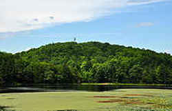 Timms hill, the highest point in
Wisconsin from across Timms Lake. The state's four highest recorded elevations are Timms Hill, Pearson Hill, Sugarbush Hill, and Rib Mountain, but
none exceeds 2,000 feet in altitude. These sites are concentrated in the north central portion of the state.
Timms hill, the highest point in
Wisconsin from across Timms Lake. The state's four highest recorded elevations are Timms Hill, Pearson Hill, Sugarbush Hill, and Rib Mountain, but
none exceeds 2,000 feet in altitude. These sites are concentrated in the north central portion of the state.
