


Wisconsin Geography: The Land
Geography and Landforms of Wisconsin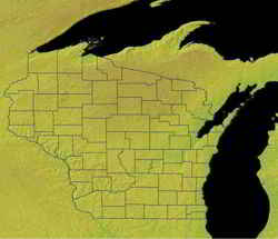

Find an overview of Wisconsin geography, topography, geographic land regions, land areas, and major rivers.
Access Wisconsin almanac furnishing more details on the state geography, geographical and land regions, climate and weather, elevation, land areas, bordering states, and other statistical data.
Although Wisconsin is not a coastal state, it is
largely defined by water. Its eastern border is the shoreline of Lake Michigan. The northwestern border is Lake Superior. The Mississippi River forms
the border between Wisconsin and Minnesota, as well as the border between Wisconsin and Iowa. A tributary of the Mississippi, the St. Croix River,
forms the rest of the western border. Only the border between Wisconsin and Illinois to the south is dry.
Wisconsin has over 14,000 lakes, of which Winnebago is the largest. Water sports, ice-boating, and fishing are popular, as are skiing and hunting.
Public parks and forests take up one-seventh of the land, with 43 state parks, 12 state forests, 14 state trails, 3 recreational areas, and 2 national
forests.
Wisconsin Highest, Lowest, & Mean Elevations |
|
|---|---|
| Mean Elevation | 1,050 ft |
| Highest Point | Timms Hill 1,951 ft. |
| Lowest Point | Lake Michigan 579 ft. |
Wisconsin Land Area (Square Miles) |
|
| Geographic Center | In Wood County, 9 mi. SE of Marshfield Longitude: 89° 45.8'W Latitude: 44° 26.0'N |
| Total Area | 65,497.82 sq. mi. 23rd |
| Land Area | 54,310.10 sq. mi. 83.00% |
| Water Area | 11,187.72 sq. mi. 17.00% |
| Forested Land Area | 45.9% |
| Dimensions (Length - Width) |
310 miles - 260 miles |
Wisconsin: Physiographic Regions
Wisconsin comprises five physical regions.
- The Northern Highland or Superior Upland
- The Lake Superior Lowland
- Central Plain, or Central Sand Plain
- The Western Upland
- Eastern Ridges and Lowlands region
Lake Superior Lowland
The Lake Superior Lowland is a narrow plain to which the surface of the Northern Highland drops abruptly. This small flat plain area extends about 5 to 20 miles inland. It slopes gradually upwards toward the south from the shores of Lake Superior.
Eastern Ridges and Lowlands (Great Lakes Plains)
Finally, the Eastern Ridges and Lowlands region is formed by three broad, parallel limestone ridges running north-south and separated by wide and shallow lowlands. The lowest elevation in the state is in this region, along the shoreline of Lake Michigan, about 580 feet (180 metres) above sea level.
The gently rolling hills of the Eastern Ridges and Lowlands extend from Green Bay south to Illinois. It is the richest agricultural region of Wisconsin where ice-age glaciers deposited earth over limestone ridges.
Northern Highland or Superior Upland
The Northern Highland is a broad upland underlain by granitic bedrock. It contains the state's highest point, Timms Hill (1,951 feet [595 metres]), in Price county.
This area makes up about one third of the state. It reaches it's highest elevation in the north, and slopes downward to the south. It has hundreds of small lakes and heavily forested hills. The highest point in Wisconsin is Timms Hill.
Central Plain, or Central Sand Plain
The Central Plain is south of the Northern Highland and curves across the central part of the state. The Wisconsin River is located in the southern portion of this region. This is an area of buttes and mesas, unusual for this part of Wisconsin. The Western Upland slopes down gently southward to the Central Plain, or Central Sand Plain, a crescent-shaped region on sandstone stretching across the centre of the state.
Western Upland
The Western Upland is located to the west of the Central Plain and is made up of limestone and sandstone bluffs along the Mississippi
River. It extends along the Mississippi River to the border of Illinois. The southwestern portion is an area that is steeply sloped ravines and winding
ridges. Glaciers largely bypassed the southwestern and western sections of the state along the Mississippi; this dry upland is known as the Driftless
Area.
Wisconsin Landscape and Landforms:
Boreal Hardwood Transition
As the name implies, this area is a transition zone between the mixed hardwood forest to the south and the boreal forest to the north. Northern Minnesota, Wisconsin, and Michigan are in this physiographic area, as is much of southern Ontario and a small area of southeast Manitoba. The Great Lakes are a prominent ecological force in this area, affecting microclimates and forest community composition. These forest communities are a heterogeneous matrix with various oaks, maples, birch, and pines representing the southern element and spruces, tamarack, and balsam fir of boreal origin. Aspen is a common early successional species throughout.
Upper Great Lakes Plain
The Upper Great Lakes Plain covers the southern half of Michigan, northwest Ohio, northern Indiana, northern Illinois, southern Wisconsin, and small portions of southwest Minnesota and northwest Iowa. Glacial moraines and dissected plateaus are characteristic of the topography. Broadleaf forests, oak savannahs, and a variety of prairie communities are the natural vegetation types. A "Driftless Area" was not glaciated during the late Pleistocene and emerged as a unique area of great biological diversity.

