


Click Image to Enlarge
Wisconsin Counties
There are seventy-two counties in the state of Wisconsin. Wisconsin became part of the Territory of Michigan and divided into two counties: Brown County in the northeast along Lake Michigan and Crawford County in the southwest along the Mississippi River. The state of Wisconsin was created from Wisconsin Territory on May 29, 1848, with 28 counties.Lafayette County, Wisconsin
Lafayette County Education, Geography, and History
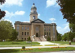
Lafayette County, sometimes spelled La Fayette County, is a county located in the state of Wisconsin. It was part of the Wisconsin Territory at the time of its founding. Based on the 2010 census, the population was 16,836. Its county seat is Darlington. The county was named in honor of the Marquis de Lafayette, the French general who rendered assistance to the Continental Army in the American Revolutionary War.
Etymology - Origin of Lafayette County Name
Named in honor of Marquis de Lafayette, of Revolutionary fame - Wis. Hist. Colls., i, p. 113.
[Source: Kellogg, Louise Phelps. "Derivation of County Names" in Proceedings of the State Historical Society of Wisconsin for 1909, pages 219-231.]
Demographics:
County QuickFacts: CensusBureau Quick Facts
Lafayette County History
Situated in the Southwestern part of Wisconsin, Lafayette County lies within the unglaciated area of the state in
the driftless region bordering the State of Illinois. With an area of 643 square miles or 411,520 acres, it has a
population of 16,263 according to the 2002 final estimate.
The first settlements perfected by permanent occupation in Lafayette County were made during the year 1824 and were
due to the existence of the lead mines, which led to early development and stability of the County. Lafayette County
was formed in 1847 when the Legislature divided Iowa County into two separate counties. The Southern portion became
Lafayette County, named after Marquis de Lafayette, hero of the Revolutionary War. Today, Lafayette County is one of
the leading agricultural counties in the state, with 1,400 farms averaging 285 acres in size. Agriculture is the
leading enterprise of the County.
John W. Hunt's 1853 Wisconsin Gazetteer
"LAFAYETTE, County, is bounded on the north by Iowa, on the east by Green, on the south by the State line, and west by Grant, and is 21 miles north and south, by 30 miles east and west. it was organized February 4, 1847. The county seat has been a vexed question since the organization, but it has finally become established at the village of Shullsburg, a few miles southwest of the geographical centre. This county is more celebrated for its mining operations than for its agricultural products, simply, however, because the former has been prosecuted to the neglect of the latter. The Peckatonnica and Fevre rivers are the principal streams. The population in 1847 was 9,335; 1850, 11,556. Dwellings, 2,079; farms, 399; manufactories, 21."
LAFAYETTE.--Population 16,060.
From: Handbook of Wisconsin by S. Silas, 1855
pg. 80-81
Lafayette is in the mineral region of Wisconsin and its products are those of the mines. A very large proportion
of the lead sent from this State is raised in Lafayette. Though the lands are rich, yet attention has so far been
attracted to its minerals, that its agricultural products have been but a small part of its riches. Under the past
system of prospecting for lead and copper, the uncertainty attending this branch of industry has turned the
attention of the miners to agriculture, and Lafayette will undoubtedly soon show a more rapid increase of wealth and
of stable prosperity than has ever attended mineral research. The land is good and mostly occupied. It lies in the
Mineral Point land district.
The Mineral Point and the Southern Wisconsin Rail Roads pass through this County.--Shullsburg is the County Seat.
Geography: Land and Water
As reported by the Census Bureau, the county has a total area of 635 square miles (1,644 km2), of which, 634 square miles (1,641 km2) of it is land and 1 square miles (3 km2) of it (0.16%) is water.
Neighboring Counties
Bordering counties are as follows:
- Grant County - west
- Iowa County - north
- Green County - east
- Stephenson County, Illinois - southeast
- Jo Daviess County, Illinois - south
Education


Click Image to Enlarge
