


Click Image to Enlarge
Wisconsin Counties
There are seventy-two counties in the state of Wisconsin. Wisconsin became part of the Territory of Michigan and divided into two counties: Brown County in the northeast along Lake Michigan and Crawford County in the southwest along the Mississippi River. The state of Wisconsin was created from Wisconsin Territory on May 29, 1848, with 28 counties.Langlade County, Wisconsin
Langlade County Education, Geography, and History
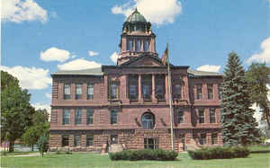
Langlade County is a county located in the state of Wisconsin. Based on the 2010 census, the population was 19,977. Its county seat is Antigo. The county was created in 1879 and organized in 1881.
Etymology - Origin of Langlade County Name
Langlade was named for Charles Langlade, formerly considered the first settler of the State. It is now known, however, that he did not permanently move to Green Bay from Mackinac until 1764, and had been preceeded by several others - Wis. Hist. Colls., xviii, p. 132. Langlade (1729-1800) was born in Mackinac, and served as an officer in the French and Indian Revoulutionary wars. He became the most prominent citizen of the small French settlement at Green Bay, where he had an estensive fur-trading establishment.
[Source: Card file at the WHS Library reference desk]
Demographics:
County QuickFacts: CensusBureau Quick Facts
Langlade County History
Langlade County (formerly New County), created in 1879 from previously unorganized territory, is named after Charles
de Langlade, who led Indian forces for the French, fought for colonists in the Revolutionary War, and was a United
States Indian Agent in Green Bay. Located in northeast Wisconsin, the county seat in Antigo.
Polish and Czech immigrants were some of the earliest settlers in Langlade County. This article looks at the history of the county and its people through the development of local schools.
Langlade County History by School Districts
Geography: Land and Water
As reported by the Census Bureau, the county has a total area of 888 square miles (2,300 km2), of which, 873 square miles (2,260 km2) of it is land and 15 square miles (39 km2) of it (1.71%) is water.
Neighboring Counties
Bordering counties are as follows:
- Oneida County - northwest
- Forest County - northeast
- Oconto County - east
Menominee County - southeast - Shawano County - south
- Marathon County - southwest
- Lincoln County - west
Education


Click Image to Enlarge
