


Massachusetts Geography: The Land
Geography and Landforms of Massachusetts
 Find an overview of Massachusetts
geography, topography, geographic land regions, land areas, and major rivers.
Find an overview of Massachusetts
geography, topography, geographic land regions, land areas, and major rivers.
Access Massachusetts almanac, furnishing more details on the state geography, geographical and land regions, climate and weather, elevation, land areas, bordering states, and other statistical data.
Massachusetts is 45th in size among the states. At its widest point, it is 190 miles from East to West and 50 miles from North to South.
Massachusetts has a coastline of 192 miles. Massachusetts' highest point, Mount Greylock, is found in the Berkshire Hills region, to the west of the Connecticut Valley Lowland. Mount Greylock is 3,491 feet above sea level. The 10-mile wide Berkshire Valley borders this area to the west.
Massachusetts Highest, Lowest, & Mean Elevations |
|
|---|---|
| Mean Elevation | 500 ft. |
| Highest Point | Mt. Greylock 3,487 ft. |
| Lowest Point | Atlantic Ocean Sea level |
Massachusetts Land Area (Square Miles) |
|
| Geographic Center | In the town of Rutland in Worcester County Longitude: 72° 1.9'W Latitude: 42° 20.4'N |
| Total Area | 10,554.57 sq. mi. 44th |
| Land Area | 7,840.02 sq. mi. |
| Water Area | 2,714.55 sq. mi. 25.71% |
| Forested Land Area | 65.1% |
| Dimensions (Length - Width) |
190 miles - 50 miles |
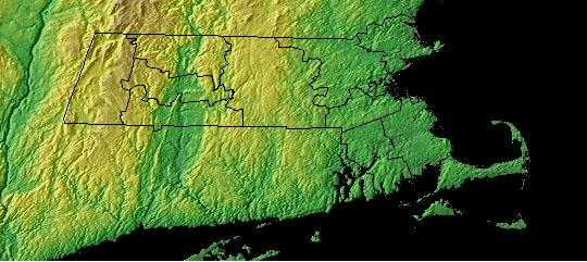
Massachusetts: Physiographic Regions
The state can be divided into six land areas:
Coastal Lowlands
The Coastal lowlands start in the east at the Atlantic Ocean and include the Elizabeth Islands, Martha's Vineyard, and Nantucket Islands. The landscape is characterized by rounded hills, swamps, small lakes and ponds, and short, shallow streams and rivers. Yesterday's Island.
Eastern New England Upland
This area spreads westward from the Coastal Lowlands forty to sixty miles, rising to about 1,000 feet above sea level and, then, gradually sloping downward in the west to meet the Connecticut Valley Lowland. The Eastern New England Upland actually extends from Maine to New Jersey and is considered an extended part of the White Mountains of New Hampshire.
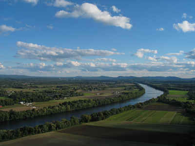
Connecticut Valley Lowland
This area is a long, narrow land area that extends from northern Massachusetts to southern Connecticut. The Connecticut River runs through this area providing fertile soil for farming. In Massachusetts the Connecticut Valley Lowland is about 20 miles wide.
Western New England Upland
The land in this area rises in elevation from the Connecticut Valley to heights of over 2,000 feet above sea level. Twenty to thirty miles wide in Massachusetts, the Western New England Upland is home to the Berkshire Hills and Mount Greylock, the highest point in Massachusetts at 3,487 feet above sea level. This land area runs from Vermont through Massachusetts down into Connecticut and is an extension of the Green Mountains of Vermont.
Berkshire Valley
This area is to the west of the Western New England Upland. This narrow valley, less than ten miles wide, runs between the Berkshire Hills to the east and the Taconic Mountains to the west. The valley is covered with green meadowlands.
Taconic Mountains
It lies on the extreme western border of Massachusetts. Less than six miles wide, this narrow band of hills stretches from northwestern Massachusetts to the south rising upward to Mt. Everett 2,602 feet above sea level.
Massachusetts Landscape and Landforms:
Northern New England
The Northern New England physiographic area extends from southern Maine through southern New Hampshire and Vermont and western Massachusetts, barely entering eastern New York in the Taconic Highlands. Landforms within the planning unit include Vermont's Killington Peak at 1,290 m ranging down to sea level along the Maine coast. Most of the region consists of Rolling hills and small mountains with large areas of farmland of the Connecticut, Merrimac, Androscoggin, and Kennebec river valleys. The planning unit also contains a large portion of the Green Mountain National Forest in southern Vermont. A majority of the planning unit is dominated by either sugar maple-beech-birch forest, red spruce-balsam fir forest, mesic hardwood forests dominated by northern red oak, or drier forests dominated by oak-hickory or pine-oak association. Presettlement forests in much of the region consisted largely of white pine and hemlock, with hardwood forests dominating after timber removal and other disturbance. Today, agriculture remains an important land use, but forest harvesting too shapes the habitats throughout Northern New England. Human populations have grown tremendously in this area and development for single family housing especially in rural and suburban areas is especially important.
Southern New England
The Southern New England physiographic area covers parts of northern New Jersey, southern New York including Long Island, the majority of Connecticut, all of Rhode Island, most of eastern Massachusetts, the southeastern corner of New Hampshire, and south-coastal Maine. This area has experienced the greatest amount of urbanization of any part of the Northeast, including the entire Boston-to-New York City corridor. Urbanization and associated human activities severely threaten remaining high-priority habitats, especially maritime marshes and dunes, relict grasslands, and mature deciduous forests. Forest fragmentation, which is not a major issue in most parts of the Northeast, is a severe factor threatening forest bird populations. Currently, urban land covers roughly one-third of the physiographic area, with an additional 25 % of the region in agricultural production, primarily in the Connecticut River Valley, eastern Long Island, and northern New Jersey. Remaining forests are a mixture of oak-hickory and other hardwoods, white pine-red pine forest, and pine-oak woodlands or barrens.

