


Click Image to Enlarge
Idaho Counties
There are forty-four Counties in Idaho. When Idaho became a territory in March, 1863, there were four Counties in existence: Boise, Idaho, Nez Perce and Shoshone. By the time Idaho became a state, there were 15 counties. The rest of the 44 Counties came into existence during the 30 years after Idaho became a state. Two of the former counties disappeared during this time. Alturas, which was created in 1864, was later divided into the many counties now found in central Idaho. Logan County was only in existence for six years, from 1889 to 1895. It was combined with Alturas to form Blaine County and Lincoln County, which was formed just two weeks after Logan lost its identity.Fremont County, Idaho
Fremont County Education, Geography, and History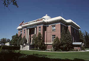
Fremont County is a county located in the state of Idaho. Based on the 2010 census, the county had a
population of 13,242. The county was created in 1893.
The county seat and largest city is
St. Anthony. Fremont county is named for the explorer John C. Fremont.
Fremont County is part of the Rexburg, ID Micropolitan Statistical Area, which is also included in the Idaho Falls-Rexburg-Blackfoot, ID
Combined Statistical Area.
Etymology - Origin of Fremont County Name
Fremont County is named for John Charles Fremont (1813-1890), a famous explorer and US Senator.
Demographics:
County QuickFacts: CensusBureau Quick Facts
Fremont County History
Established March 4, 1893 with its county seat at St. Anthony. Named for John C. Fremont, an explorer known as the "Pathfinder" who passed through the area in 1843. The first settlement in the county was Egin Bench in 1879.
Geography: Land and Water
As reported by the Census Bureau, the county has a total area of 1,896 square miles (4,910 km2), of which 1,864 square miles (4,830 km2) is land and 32 square miles (83 km2) (1.7%) is water.
Fremont county is located in east Idaho. The southern part of the county cover the northeast tip of the Snake River Basin, with the mountains of the continental divide forming its northern boundary. Montana lies to the north, and Wyoming to the east. A portion of Yellowstone National Park reaches into the county.
Neighboring Counties
Bordering counties are as follows:
- North: Gallatin County, Mont.
- East: Teton County, Wyo.
- South: Teton County; Madison County
- Southwest: Jefferson County
- West: Clark County
- Northwest: Beaverhead County, Mont.; Madison County, Mont.
Education


Click Image to Enlarge
