


Click Image to Enlarge
Idaho Counties
There are forty-four Counties in Idaho. When Idaho became a territory in March, 1863, there were four Counties in existence: Boise, Idaho, Nez Perce and Shoshone. By the time Idaho became a state, there were 15 counties. The rest of the 44 Counties came into existence during the 30 years after Idaho became a state. Two of the former counties disappeared during this time. Alturas, which was created in 1864, was later divided into the many counties now found in central Idaho. Logan County was only in existence for six years, from 1889 to 1895. It was combined with Alturas to form Blaine County and Lincoln County, which was formed just two weeks after Logan lost its identity.Madison County, Idaho
Madison County Education, Geography, and History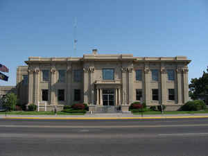
Madison County is a county located in the state of Idaho. Based on the 2010 census, the
population was 37,536. Madison County was
created on February 18, 1913. The county
seat and
largest city is Rexburg. The county is named in
honor of James Madison (1751-1836), fourth President of the United
States (1809-1817).
Madison County is part of the Rexburg, ID Micropolitan Statistical Area, which is also included in the Idaho Falls-Rexburg-Blackfoot, ID
Combined Statistical Area.
Etymology - Origin of Madison County Name
Madison County is named for James Madison (1751-1836), President of the United States from 1809 to 1817.
Demographics:
County QuickFacts: CensusBureau Quick Facts
Madison County History
Established February 18,1913 with its county seat at Rexburg. Named for President James Madison, the fourth
president of the United States. First settlers in the county were Mormon families from Utah, who built the first
irrigation system.
Geography
As reported by the Census Bureau, the county has a total area of 473 square miles (1,230 km2), of which 469 square miles (1,210 km2) is land and 4.0 square miles (10 km2) (0.8%) is water.
Madison county is located in east Idaho. The county is the third-smallest county in Idaho by area. Part of Targhee National Forest is located in this county.
Neighboring Counties
Bordering counties are as follows:
- Northeast: Fremont County
- East: Teton County
- South: Bonneville County
- West: Jefferson County
Education


Click Image to Enlarge
