


Click Image to Enlarge
Idaho Counties
There are forty-four Counties in Idaho. When Idaho became a territory in March, 1863, there were four Counties in existence: Boise, Idaho, Nez Perce and Shoshone. By the time Idaho became a state, there were 15 counties. The rest of the 44 Counties came into existence during the 30 years after Idaho became a state. Two of the former counties disappeared during this time. Alturas, which was created in 1864, was later divided into the many counties now found in central Idaho. Logan County was only in existence for six years, from 1889 to 1895. It was combined with Alturas to form Blaine County and Lincoln County, which was formed just two weeks after Logan lost its identity.Oneida County, Idaho
Oneida County Education, Geography, and History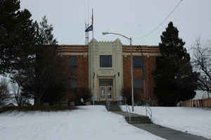
Oneida County is a county located in the state of Idaho. Based on the 2010 census, the county had a population of 4,286. Oneida County was created on January 22, 1864. The county seat and largest city is Malad City. The county is named for Oneida Lake in New York state, where many early settlers were from.
Etymology - Origin of Oneida County Name
Oneida County is named for the Oneida Lake area of New York from which many early settlers hailed.
Demographics:
County QuickFacts: CensusBureau Quick Facts
Oneida County History
Established January 22, 1864 with its county seat at Soda Springs. In 1866 it was moved to Malad City, because of its growth and its location on the stagecoach line and freight road between Corinne, Utah, and the mines in Butte, Montana. Named for Lake Oneida, New York, the area from which most of the early settlers had emigrated. Most of the county's population lives in Malad City and the surrounding Malad Valley.
Geography: Land and Water
As reported by the Census Bureau, the county has a total area of 1,202 square miles (3,110 km2), of which 1,200 square miles (3,100 km2)
is land and 1.5 square miles (3.9 km2) (0.1%) is water.
Oneida county is located in southeast Idaho.
Elkhorn Peak is the county's highest point, at 9,095 feet (2,772 m) above sea level. Alternating valleys and ridges of mountains or hills
typify the topography, with grassland and sagebrush covering most areas. The Curlew National Grassland lies within the county.
Neighboring Counties
Bordering counties are as follows:
- Northeast: Bannock County
- East: Franklin County
- Southeast: Cache County, Utah
- Southwest: Box Elder County, Utah
- West: Cassia County
- Northwest: Power County
Education


Click Image to Enlarge
