


Click Image to Enlarge
Mississippi Counties
There are eighty counties in Mississippi. Two original counties were Adams County and Jefferson County (formerly Pickering) established in 1799Carroll County, Mississippi
Carroll County Education, Geography, and History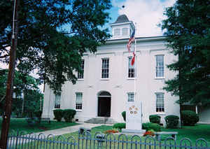
Carroll County is a county located in the state of Mississippi. Based on the 2010 census, the population was 10,597. Its county seats are
Carollton and Vaiden Mississippi. The county is named for Charles Carroll of Carrollton, the last surviving signatory of the US Declaration
of Independence.
Carroll County is part of the Greenwood, MS Micropolitan Statistical Area. It is inside the Mississippi Delta, although most of its land is in
the hill country.
Etymology - Origin of Carroll County Name
Carroll is named for Charles Carroll of Carrollton, last surviving signer of the US Declaration of Independence. Charles Carroll of Carrollton (September 19 1737 - November 14 1832) was a delegate to the Continental Congress and later United States Senator for Maryland. He was the only Catholic signer of the Declaration of Independence. He was the longest lived signer of the Declaration of Independence and the Continental Congress, dying at the age of 95.
Demographics:
County QuickFacts: CensusBureau Quick Facts
Carroll County History
Carroll County was established by the Mississippi legislature on December 23, 1833 from land ceded by the Choctaw Indians under the Treaty of Dancing Rabbit Creek 1830. It was named for Charles Carroll, one of the men who signed the Declaration of Independence. Because of it's original size, 908 square miles, Carroll County has two county seats, Carrollton and Vaiden.
In 1870, large portions of Carroll County were used to form three other counties - Leflore, Grenada, and Montgomery,
reducing the county to its present size of 615 square miles.
Geography: Land and Water
As reported by the Census Bureau, the county has a total area of 635 square miles (1,643 km2), of which, 628
square miles (1,626 km2) of it is land and 7 square miles (18 km2) of it (1.07%) is water.
Neighboring Counties
Bordering counties are as follows:
- Grenada County (north)
- Montgomery County (east)
- Attala County (southeast)
- Holmes County (south)
- Leflore County (west)
Education
Carroll County School District is the area public school district.
Carroll Academy is an area private school which is financially supported by the Council of Conservative Citizens, a white supremacist group.
Pillow Academy in unincorporated Leflore County, near Greenwood, enrolls some students from Carroll County. It originally was a segregation
academy.


Click Image to Enlarge
