


Click Image to Enlarge
Mississippi Counties
There are eighty counties in Mississippi. Two original counties were Adams County and Jefferson County (formerly Pickering) established in 1799Madison County, Mississippi
Madison County Education, Geography, and History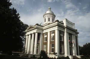
Madison County is a county located in the state of Mississippi. Based on the 2010 census, the population was 95,203. The county seat is
Canton. The county is named for US President James Madison.
Madison County is part of the Jackson, MS Metropolitan Statistical Area.
Etymology - Origin of Madison County Name
Madison is named for US President James Madison.
Demographics:
County QuickFacts: CensusBureau Quick Facts
Madison County History
Madison County was established January 29, 1828, and named for James Madison, fourth President of the United States. Embraced within the territory ceded by the Choctaws in 1820, and long known as the "New Purchase," it was originally a part of the old county of Hinds. In 1823 Hinds surrendered a large section of its area to form the county of Yazoo, and five years later, that portion of Yazoo lying east of the Big Black River, was taken to form the county of Madison. The act creating the county recites that
"So much of the county of Yazoo as lies east of the Big Black River, beginning on the east bank of said river, where the Hinds County line strikes the same; thence with the said line to Pearl River; thence up said river to the Choctaw boundary line; thence with said boundary line, to where it strikes the Big Black; thence down the Big Black River to the beginning." December 23, 1833, the county was enlarged by adding "the territory south of the line drawn from the western boundary of Leake County, through the center of township 12 of range 5 east, and extended west to the old Choctaw boundary, and thence west to the Big Black River, and west of Leake County."
February 22, 1840, the present boundary line between Madison and Hinds counties was established.
Madison County had a population of 3,675 whites and 11,238 slaves as early as 1837, and had 89,746 acres under
cultivation in 1836. Many of the old settlements of the region, such as Runnelsville, Williamsburg, Madisonville,
Livingston and Vernon, are now extinct or moribund. The first courts of the county were held at Beattie's Bluff, on
the Big Black River, and boats ascended the river to this point. The first permanent county seat was located at the old
town of Livingston, situated about 15 miles southwest of Canton, and at one time the most important town in the
county. It began to decay when the county seat was changed to Madisonville. The present county site was finally
established at Canton, near the center of the county. Some of the other important towns in the county are Madison,
Ridgeland, Flora, Sharon and Miliville. In the northeast corner of the county formerly stood the old historic home
of Governor McWillie, "Kirkwood," long known as one of the most beautiful and hospitable homes in the South, and a
refuge for its war-worn sons during the War for Southern Independence.
Geography: Land and Water
As reported by the Census Bureau, the county has a total area of 742 square miles (1,922 km2), of which, 717
square miles (1,857 km2) of it is land and 25 square miles (64 km2) of it (3.35%) is water. The southestern border
of the county is defined by the old course of the Pearl River before it was dammed to create the 33,000 acre (134
km2) Ross Barnett Reservoir.
Neighboring Counties
Bordering counties are as follows:
- Attala County (north)
- Leake County (east)
- Scott County (southeast)
- Rankin County (south)
- Hinds County (southwest)
- Yazoo County (west)
Education


Click Image to Enlarge
