


Click Image to Enlarge
Mississippi Counties
There are eighty counties in Mississippi. Two original counties were Adams County and Jefferson County (formerly Pickering) established in 1799Scott County, Mississippi
Scott County Education, Geography, and History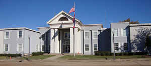
Scott County is a county located in the state of Mississippi. Based on the 2010 census, the population was 28,264. Its county seat is Forest. The county is named for Abram M. Scott, the Governor of Mississippi from 1832 to 1833.
Etymology - Origin of Scott County Name
Scott is named for Governor of Mississippi Abram M. Scott. Abram Marshall Scott (1785-July 12 1833, age 47-48)
was a Democratic Mississippi politician born in South Carolina. He served in the state senate in 1822 and 1826-1827.
In 1832, he was sworn in as Governor and served until his death by cholera on July 12, 1833.
Demographics:
County QuickFacts: CensusBureau Quick Facts
Scott County History
Scott County was organized on the 23d of December, 1833, and was named in honor of Abram M. Scott, seventh governor of Mississippi.
The act which established the county defined its boundaries as follows:
"Beginning at the northwest corner of Jasper County, and running from thence north, with the line between ranges 9 and 10 east, to the line between the townships 8 and 9, from thence west with said line to the line between ranges 5 and 6 east; from thence south with said line to the western boundary of the Choctaw nation; from thence directly south, to a point directly west of the line, between townships 4 and 5; and from thence east with said line to the place of beginning."
February 8, 1838, the county was enlarged by the addition of "all that portion of territory lying east of Pearl
River and the old Choctaw boundary line, designating the dividing line between the Indian and white settlements
prior to the treaty of Dancing Rabbit Creek, in 1830, from the point where the said boundary line crosses Pearl
River, to the point where the same intersects the present western boundary line of the county of Scott."It is now a
nearly square area of land containing 597 square miles of territory, and was one of the sixteen counties formed at
the above time from the territory ceded by the Choctaws in the treaty of Dancing Rabbit, September 27, 1830.
The original county seat was located at Berryville, about four miles southwest of Forest, but after the streets were
laid out, it was abandoned within twelve months and the courthouse was removed to Hilisboro in the fall of 1836,
where it remained for thirty years. During the Civil War it was burned to the ground on Sherman's famous "March to
the Sea." On November 8, 1865, a motion was made in the legislature to relocate the county seat. The election was
held, and Forest was selected by a large majority. This caused one of the largest controversies in county history.
People from Hillsboro stormed the new courthouse and set fire to the roof in hopes of totally destroying the new
establishment. Their plot was foiled and only a small part of the courthouse was burned. People from Forest spent
the rest of the night entrenched around the courthouse with guns, determined that no harm would come to their much
desired courthouse.
The result of the first elections were then suspended, and in the next election, Forest lost decisively. The
intracounty turmoil was so great that it approached a small-scale war. Forest was dissatisfied and demanded another
election. In the first week of May, 1873, the third and last election was held, and Forest won by a large margin. It
was finally moved to Forest, on the Alabama & Vicksburg railroad.
The city of Forest has had four courthouses. The first was a frame building and the second and third were built of
brick. During the time the third courthouse was in use, people often gathered on Saturdays to listen to preachers or
other speakers. Because of a faulty foundation, this third courthouse was replaced by the building which is in use
today. All of the early courthouses had a watering trough for animals on the east side. An extensive renovation of
the latest courthouse was begun in 1996.
Geography: Land and Water
As reported by the Census Bureau, the county has a total area of 610 square miles (1,581 km2), of which, 609 square miles (1,578 km2) of it is land and 1 square miles (3 km2) of it (0.21%) is water.
Neighboring Counties
Bordering counties are as follows:
- Leake County (north)
- Newton County (east)
- Smith County (south)
- Rankin County (west)
- Madison County (northwest)
Education


Click Image to Enlarge
