


Click Image to Enlarge
Mississippi Counties
There are eighty counties in Mississippi. Two original counties were Adams County and Jefferson County (formerly Pickering) established in 1799Simpson County, Mississippi
Simpson County Education, Geography, and History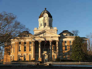
Simpson County is a county located in the state of Mississippi. Its western border is formed by the Pearl River, an important
transportation route in the 19th century. Based on the 2010 census, the population was 27,503. The county seat is Mendenhall. The county is named
for judge Josiah Simpson.
Simpson County is part of the Jackson, MS Metropolitan Statistical Area.
Etymology - Origin of Simpson County Name
Simpson is named for Judge Josiah Simpson.
Demographics:
County QuickFacts: CensusBureau Quick Facts
Simpson County History
Simpson County lies in the south central part of the State, and was organized January 23, 1824, and named in honor of Judge Josiah Simpson, a former Pennsylvanian, educated at Princeton. He later lived at Green Hill, near Natchez, and became a territorial judge of Mississippi and served as a member of the Constitutional Convention of 1917. It was part of the Choctaw cession of 1820, termed the New Purchase, and subsequently formed the eastern part of the county of Copiah (erected in 1823). It has a present area of 575 square miles. As early as 1837 it had a free white population of 2,329, slaves 891, a majority of these early settlers coming from the older portions of the State on the west and south.
At the time of it's organization, Simpson County was one of the most attractive Counties of the great Southwest and
that is why for the first twenty years after, it grew so rapidly in population. Doubtless the early settlers from
Scotland, New England, Virginia and the Carolinas sent back to their relatives glowing accounts of this new country.
The first courts of the county were held at the house of William Gibson, and in 1827 the village of Westville was
made the seat of justice. The county seat was eventually moved to Mendenhall. It was returned to Westville in the
fall of 1905, but an election in the following year decided the contest for Mendenhall..
Geography: Land and Water
As reported by the Census Bureau, the county has a total area of 591 square miles (1,529 km2), of which, 589
square miles (1,525 km2) of it is land and 2 square miles (5 km2) of it (0.30%) is water.
Neighboring Counties
Bordering counties are as follows:
- Rankin County (north)
- Smith County (east)
- Covington County (southeast)
- Jefferson Davis County (south)
- Lawrence County (southwest)
- Copiah County (west)
Education


Click Image to Enlarge
