


Hawaii State Almanac: Facts and Figures
Quick Facts, Figures, and Overview of the State of Hawaii
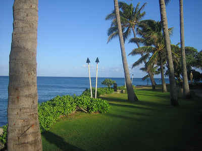
Hawaii is a Pacific state of the US. It consists mainly of the Hawaiian Islands, an archipelago near the geographic center of the North Pacific Ocean, and other islets unrelated geographically to the archipelago; in all, 8 main islands and 124 islets, reefs, and shoals. The major islands in order of size are Hawaii, Maui, Oahu, Kauai, Molokai, Lanai, Niihau, and Kahoolawe. The island archipelago is located some 2,000 miles southwest of the US mainland. The islands have been formed through continuous activity of tectonic plates. The active volcanoes of Hawaii are located in the southern half of the island named Hawa'i. The state of Hawaii is host to a whole variety of flora and fauna and a whole range of environments from its tropical climate to its high altitude.
Hawaii Name: One theory has it that Hawaii name comes from a combination of the words "Hawa" and "ii" and means a small or new homeland; "Hawa" meaning a traditional homeland and "ii" meaning small and raging. The other theory is that the name comes from the traditional discoverer of the islands, Hawaii Loa.
As agriculture has declined in importance, the economy has diversified to encompass a large tourist business and a growing manufacturing industry. The temperature is mild, and cane sugar, pineapple, and flowers and nursery products are the chief products. Hawaii also grows coffee beans, bananas, and macadamia nuts. The tourist business is Hawaii's largest source of outside income.
Hawaii Almanac: Facts and Figures on Hawaii |
|||
|---|---|---|---|
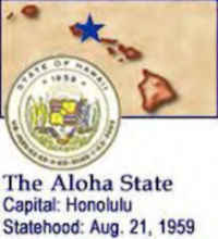
| Official Name | Hawaii | ||
| Capital | Honolulu | ||
| Nicknames | Aloha State (1959) ... and more | ||
| Motto | Ua Mau Ke Ea O Ka Aina I Ka Pono (The life of the land is perpetuated in righteousness.) | ||
| Location Region |
25.00201 N, 167.99880 W Hawaii Pacific States |
||
| Constitution Ratified | |||
| Statehood | August 21, 1959 50th State |
||
| Population | 1,360,301 (2010) 188.62 42nd |
||
| Largest City (by population) |
10 largest cities: (2010) Honolulu, 387,170; Pearl City, 47,698; Hilo, 43,263; Kailua,
38,635; Waipahu, 38,216; Kaneohe, 34,597; Mililani Town, 27,629; Kahului, 26,337; Kihei, 20,881; Wahiawa, 17,821. |
||
| Bordering States | Major Islands: (Order by size)
Hawaii, Maui, Oahu, Kauai, Molokai, Lanai, Niihau, and Kahoolawe |
||
| Major Industry | tourism, agriculture (bananas, pineapples, macadamia nuts, taro) | ||
| Major Rivers | Wailuku River (on the island of Hawaii), Anahulu River (on the island of Oahu) | ||
| Major Lakes | Salt Lake | ||
| Hawaii Counties | 4 Counties in Hawaii | ||
| Largest County (by population) |
Honolulu County | 953,207 (2010) | 600 sq. mi. |
| Largest County (by area) |
Hawaii County | 4,028 sq. mi. | |
| State forests | 19 | (over 109,000 ac.) | |
| State park | 52 | (25,000 ac.) | |
| Electoral Votes | 4 | ||
| US Congress | 2 Senators; 2 Representatives | ||
| Time Zone | Hawaii-Aleutian | ||
| Zip Codes | NANPA | ||
| State Quick Facts | Census Bureau Quick Facts | ||
Hawaii Climate and Weather |
|||
|---|---|---|---|
| The Hawaiian Island's weather is very consistent,
with only moderate changes in temperature throughout the year. There are only 2 seasons: the summer months (called Kau in Hawaiian) that extend from May to October and the winter months (Ho'oilo) that run from November to April. The average day-time summer temperature at sea level is 85 degrees F. (29.4 C) while the average day-time winter temperature is 78 degrees (25.6 C). |
|||
| Highest Temperature | 100 degrees April 27, 1931 - Pahala |
||
| Lowest Temperature | 12 degrees May 17, 1979 -Mauna Kea |
||
| Avg. Temp: High - Low |
87.1 degrees 65.3 degrees |
||
Hawaii Points of Interest |
|||
| The endless variety of glorious beaches, especially Poipu, Sunset and Waikiki, the old whaling town of Lahaina, spectacular Kona Coast, Pearl Harbor, Haleakala National Park, Hawaii Volcanoes National Park and Kilauea, Na Pali Coast and Waimea Canyon. Among the major points of interest are Haleakala National Park (Maui), Puuhonua o Honaunau National Historical Park (Hawaii), Polynesian Cultural Center (Oahu), the USS Arizona and USS Missouri Memorial at Pearl Harbor, The National Memorial Cemetery of the Pacific (Oahu), and Iolani Palace (the only royal palace in the U.S.), and Bishop Museum - to name but a few. | |||
Hawaii Highest, Lowest, and Mean Elevations (Feet) |
|||
| Mean Elevation: 3,030 feet | |||
| Highest Point: Puu Wekiu, Mauna Kea: 13,796 feet
|
|||
| Lowest Point: | Pacific Ocean Sea level |
||
Hawaii Land Area (Square Miles) |
|||
| Geographic Center | Between islands of Hawaii and Maui Longitude: 157°15.6'W Latitude: 20°57.1'N |
||
| Total Area | 10,930.98 sq. mi. 43rd |
||
| Land Area | 6,422.62 sq. mi. | ||
| Water Area | 4,508.36 sq. mi. 41.24% |
||
| Forested Land Area | 42.5% | ||
| Dimensions (Length - Width) |
1600 miles - 93 miles | ||
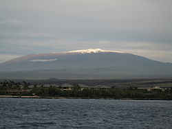 Mauna Kea is the tallest
mountain in the Hawaiian Chain. Its summit rises to an elevation of 4205m above sea level and it is located on the island of Hawaii. It is the second
largest in subaerial surface area of the five shield volcanoes that comprise the island of Hawaii.
Mauna Kea is the tallest
mountain in the Hawaiian Chain. Its summit rises to an elevation of 4205m above sea level and it is located on the island of Hawaii. It is the second
largest in subaerial surface area of the five shield volcanoes that comprise the island of Hawaii.
