


Connecticut State Almanac: Facts and Figures
Quick Facts, Figures, and Overview of the State of Connecticut
Connecticut is the southernmost of the New England states of the US. Connecticut is bordered by Long Island Sound, New York State, Massachusetts and Rhode Island. The state capital of Connecticut is Hartford and other major cities are New Haven, New London, Norwich, Bridgeport etc. Connecticut's name is a particular reference to the Connecticut River. The word itself was translated from the Indian name "Quinnehtukqut" and means "beside the long tidal river."
By the mid-19th century the state's economy was dominated by manufacturing, and Hartford, its capital, had become one of the chief centers of the US insurance industry. Today, Connecticut factories produce weapons, sewing machines, jet engines, helicopters, motors, hardware and tools, cutlery, clocks, locks, silverware, and submarines. Hartford has the oldest US newspaper still being published- the Hartford Courant, established 1764- and is the insurance capital of the nation.
Connecticut leads New England in the production of eggs, pears, peaches, and mushrooms, and its oyster crop is the nation's second largest. Poultry and dairy products also account for a large portion of farm income.
Connecticut Almanac: Facts about Connecticut |
|
|---|---|
| Official Name | Connecticut |
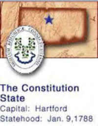
| Capital | Hartford |
| Nicknames | The Constitution State (Official: 1959) ...and more |
| Motto | Qui Transtulit Sustinet (He who transplanted still sustains) |
| Location Region |
41.76570 N, 072.68386 W New England Northeastern |
| Constitution Ratified | Dec. 30, 1965 |
| Statehood | January 09, 1788 5th State |
| Population | 3,574,097 (2010) 702.90 sq. mi. 29th |
| Largest City (by population) |
10 largest cities (2010): Bridgeport, 144,229; New Haven, 129,779; Hartford, 124,775; Stamford, 122,643; Waterbury, 110,366; Norwalk, 85,603; Danbury, 80,893; New Britain, 73,206; Meriden, 60,868; Bristol, 60,477 |
| Bordering States | North: Massachusetts East: Rhode Island South: Long Island Sound West: New York State |
| Major Industry | agriculture, industry (especially insurance), tourism |
| Major Rivers | Connecticut River, Housatonic River, Thames River |
| Major Lakes | Lake Candlewood |
| Connecticut Counties | 8 Counties in Connecticut |
| Largest County (by population) |
Fairfield County 916,829 (2010) 626 sq. mi. |
| Largest County (by area) |
Litchfield County 920 sq. mi. |
| State forests | 94 (170,000 ac.) |
| State parks | 94 (32,960 ac.) |
| Presidential Birthplace | George Walker Bush was born in New Haven on July 6, 1946 (he is the 43rd US President, serving from 2001 to the present) |
| Electoral Votes | 7 (as of the 2004 Presidential Election) |
| US Congress | 2 Senators; 6 Representatives (5 Representatives as of the 2002 election) |
| Time Zone | Eastern Standard Time |
| Zip Codes | NANPA |
| State Quick Facts | Census Bureau Quick Facts |
Connecticut Climate and Weather |
|
|---|---|
| Connecticut lies at the crossroads where the New England climate zone ends... and the Middle Atlantic climate zone begins. Connecticut is located near 40 - 41 latitude ( about the same as northern Japan or the northern Mediterranean (Naples, Italy and New Haven, CT are located at the same latitude). There really is two main seasons in the Tri-State area (NY/NJ/CT): A warm to hot season from April to late October...and a cool to cold season from November through mid March. | |
| Highest Temperature | 105 degrees Jul. 22, 1926 - Waterbury |
| Lowest Temperature | -32 degrees Feb. 16, 1943 - Falls Village |
| Avg Temp: High - Low |
84.8 degrees 16.7 degrees |
Connecticut Points of Interest |
|
|
For those seeking
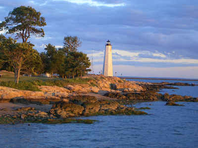
an outdoor adventure, or an historic journey through early America, Connecticut has it all. The charming State of Connecticut's most popular attractions include a popular resort area with its 250-mile Long Island Sound shoreline and many inland lakes. Among the major points of interest are Yale University's Gallery of Fine Arts and Peabody Museum. Other famous museums include the P. T. Barnum, Winchester Gun, and American Clock and Watch. The town of Mystic features a re-created 19th-century New England seaport and the Mystic Marinelife Aquarium. |
|
Connecticut Highest, Lowest, and Mean Elevations (Feet) |
|
| Mean Elevation: 500 feet | |
| Highest Point: Mt. Frissell, on south slope: 2,380 feet
|
|
| Lowest Point: | Long Island Sound Sea level |
Connecticut Land Area (Square Miles) |
|
| Geographic Center | In Hartford County, at East Berlin Longitude: 72°42.4'W Latitude: 41°35.7'N |
| Total Area | 5,543.33 sq. mi. 48th |
| Land Area | 4,844.80 sq. mi. 87.40% |
| Water Area | 698.53 sq. mi. 12.60% |
| Forested Land Area | 60.1% |
| Dimensions (Length - Width) |
110 miles - 70 miles |
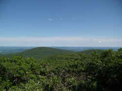 While Bear Mountain
is the highest summit in Connecticut, the highest point in that state is on the south slope of Mount Frissell, along the Mount Frissell
trail, a little to the west of the summit.
While Bear Mountain
is the highest summit in Connecticut, the highest point in that state is on the south slope of Mount Frissell, along the Mount Frissell
trail, a little to the west of the summit.
